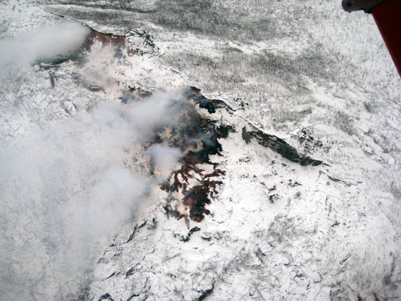
 Could it be possible that Alaska has the world’s oldest man made pyramids? And, if true, is the recent snow and ice melting going to reveal even more ancient structures in the future? Amazingly, a small team of explorers has just announced that they have indeed found at least two ancient pyramids. Currently, only the upper portions of the pyramids are exposed but the general shape is obvious. The team was able to find the outer rock edges of one pyramid and the stones were obviously stacked one on top of the other (comparable to Egypt pyramids). The team actually made the discovery by accident while on a hiking expedition. “What the geologists said they found under Alaska, was a pyramid bigger than the one in Egypt.” In this exclusive EMN video shot at Contact In The Desert, Joshua Tree, California, investigative reporter Linda Moulton Howe shares her research about an alleged pyramid buried beneath Alaska and how it relates to the gods of antiquity. Linda Moulton Howe: The Ancient Pyramid of Alaska is Real
0 Comments
 A team of researchers from Copenhagen Universityhave located a single mutation that causes the mysterious phenomenon of blue eyes. And all blue eyed people are genetically related to a person who lived in the Black Sea region sometime between 6 – 10,000 years ago. The research was published in the Journal of Human Genetics. A mutation in a gene called OCA2 came into being nearly 8,000 years ago. It can be definitively traced back to an ancestor from the Black Sea. Dr. Hans Eiberg claims that before this time, every human being had brown eyes. “A genetic mutation affecting the OCA2 gene in our chromosomes resulted in the creation of a ‘switch,’ which literally ‘turned off’ the ability to produce brown eyes,” Eiberg said. When blue-eyed peoples from Jordan, Denmark and Turkey were examined, their genetic difference was traced back to the maternal lineage according to Eiberg’s team. The brown melanin pigment is still dominant. However, following the last Ice Age, Europeans developed this rare mutation that differentiated them from the rest of the human race. Ninety-five percent of Europeans in Scandinavian countries have blue eyes. They are also found to have a greater range of hair and skin color. Comparatively, Europe has a wider variety of hair color and skin pigment than is found in any other continent in the world. These mutations are recent as Europe was colonized only a few thousand years ago, say mainstream scientists. Through interbreeding, the brunette with blue eyes was evidenced about 25,000 years ago. Researchers attribute this to ancient interbreeding with Neanderthals. Although no Neanderthal DNA has been found in modern Homo Sapien-Sapien, mainstream science clings to this theory as fact because they haven’t come up with anything better. “The question really is, ‘Why did we go from having nobody on Earth with blue eyes 10,000 years ago to having 20 or 40 percent of Europeans having blue eyes now?” John Hawks of the University of Wisconsin-Madison said. “This gene does something good for people. It makes them have more kids.” 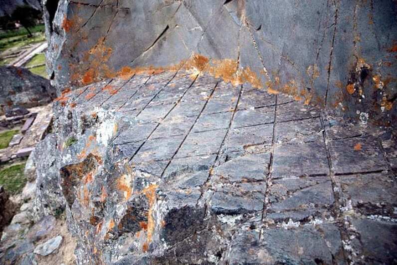 Located near Cuzco modern day Peru, we find one of the most mysterious yet magnificent ancient site son the planet: Ollantaytambo. There — according to many — we can find evidence of extremely advanced technology used by ancient cultures thousands of years ago. What kind of ancient technology could have left behind such intricate criss-cross patterns in Andesite rock? Located in the so-called Inca sacred valley, this ancient marvel of engineering is believed to have been built around 1440 AD by Inca Emperor Pachacuti. However, many researchers believe this ancient ‘fortress’ dates back much further in time than we can imagine. Ollantaytambo can be compared in greatness to other sites like Puma Punku, Teotihuacan and even the Pyramids of Giza. Thousands of years after Ollantaytambo was built, archaeologists and researchers still fail to explain how exactly ancient mankind was able to quarry, transport and put into place massive blocks of stone weighing over 50 tons each. Some of the stonework present at Ollantaytambo even display what many call evidence of ‘extremely advanced ancient technology’ that has been lost for thousands of years. What have we missed at Ollantaytambo? Is it possible that this ancient site was built solely with the use of wooden and copper tools? How did the ancients manage to cut massive rocks out of the mountain, transport them across the plains, moving them across rivers and bring them up and position where they are found today? Ollantaytambo is a marvel of engineering and architecture, it’s both a fortress and complex city, and many questions have been raised throughout history regarding the construction of this ancient site. Looking at Ollantaytambo we find one particular location of extreme interest. On the mountains from where the ancients somehow cut out massive pieces of rock, there are strange yet extremely precise criss-cross patterns. These patterns — according to many — seem as if they were left behind by some sort of machinery after the slabs were removed. What kind of technology could have left behind such patterns thousands of years ago? 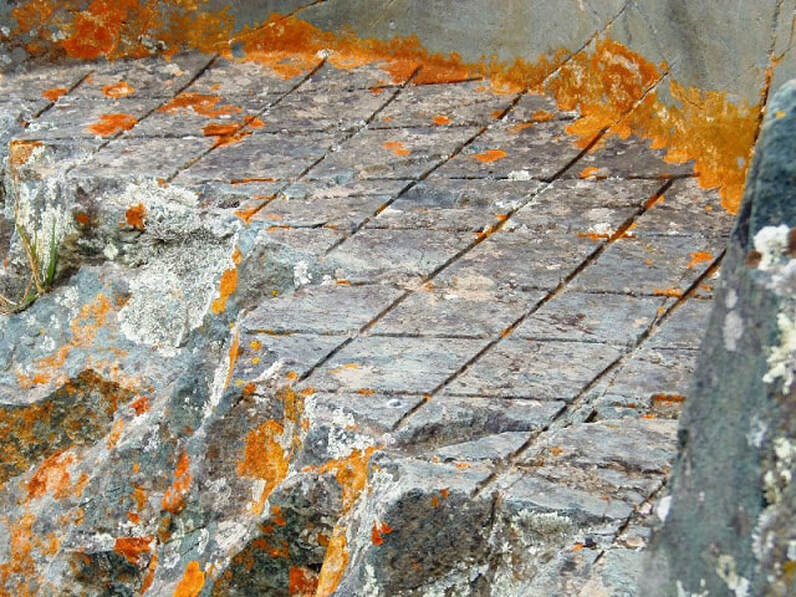 Some have even ventured out and said that these fascinating criss-cross patterns are in fact marks that could have been created by some sort of laser-like apparatus, or saw machine, pointing to the possibility that thousands of years ago, ancient builders of sites such as Ollantaytambo, Tiahuanaco, and Puma Punku had in their possession long-lost technology that allowed them to quarry with ease, massive andesite blocks. “The rock surface looks rough but when you touch it feels as smooth as a bathroom mirror, which means some type of vitrification process was used. At the bottom of where this alcove was cut out, we can see a criss-cross pattern, in my opinion, they are actually saw marks, to me, and this pattern is irrefutable proof for ancient machining.” – Giorgio A. Tsoukalos Look at these pictures and ask yourself: Is it possible that all of this was achieved thousands of years ago with bronze and copper tools? Many people firmly believe that the “Bronze tool” theory just doesn’t add up. What kind of ancient technology could have left behind such intricate criss-cross patterns? 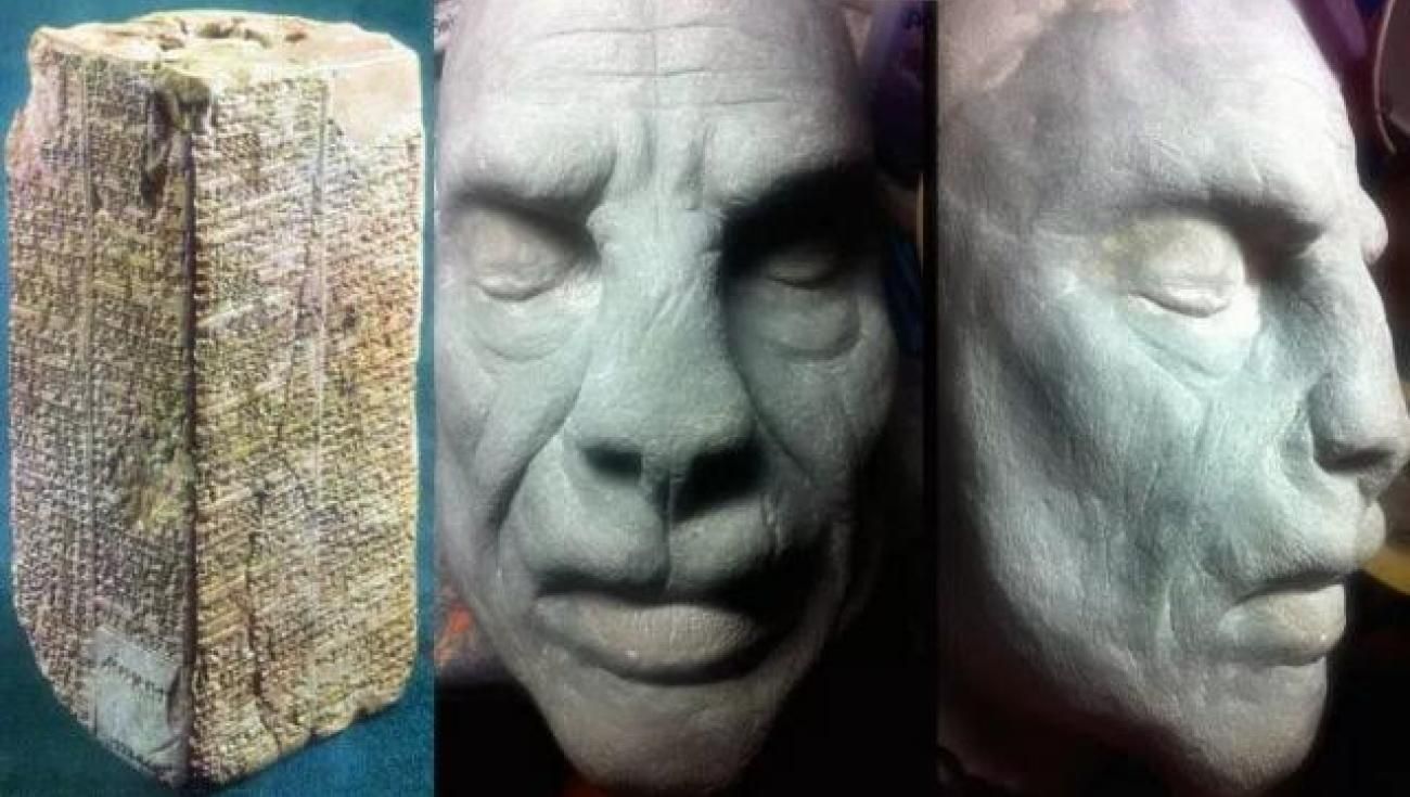 Uncovered throughout the years by scholars in numerous regions in ancient Mesopotamia, the copies of what is believed to be a single manuscript — refered to as the Sumerian King List — details how in the distant past, our planet was ruled by eight mysterious kings for a staggering period of 241,000 years. The list even states that these rulers ‘descended from the heaven’. The Sumerian King list tells an amazing story which many find hard to believe. Referred to as the Sumerian King List — this ancient manuscript details how in the distant past, our planet was ruled by eight mysterious kings for a staggering period of 241,000 years. “…After the kingship descended from heaven, the kingship was in Eridug. In Eridug, Alulim became king; he ruled for 28800 years. Alaljar ruled for 36000 years. 2 kings; they ruled for 64800 years…” “…In 5 cities 8 kings; they ruled for 241,200 years. Then the flood swept over…” that is written on the first part of the Sumerian King List. But, how is it possible that eight kings ruled over Earth for 241,000 years? Experts believe the answer is simple: the list blends prehistorical and ‘mythological dynastic rulers,’ who enjoyed implausible lengthy reigns with more plausibly historical dynasties. In other words, scholars are telling us that some things written in the Sumerian king list are correct, while others – like the implausibly lengthy reigns — just can’t be. Furthermore, not only does the Sumerian King List tell us for how long these kings ruled on Earth, it specifically says that these eight kings ‘descended from heaven’, after which they ruled for an astonishingly long period. Interestingly, the list further details how these eight kings met their end during the Great Flood that swept across the Earth. The list also details what occurred after the flood, as clearly states written that ‘another kingship was lowered from heaven,’ and these mystery Kings once again ruled over man. 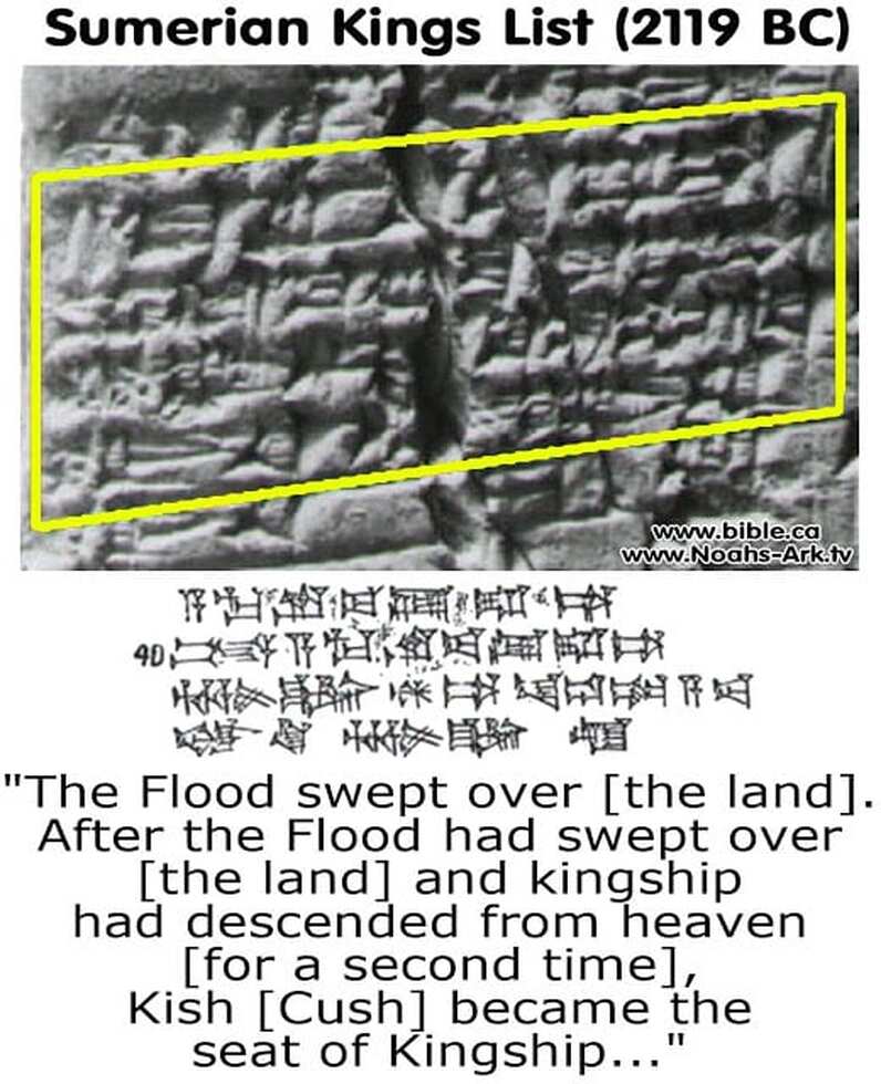 But is the Sumerian King list a mixture of historically verifiable kings and mythological beings? Or is it possible that scholars have merely categorized some of the rulers as mythological, due to their peculiar characteristics? For decades people believed that the story detailed in the Sumerian King List – the incredibly long-lived kings, their demise during the Great Flood, and their replacement from new kings who came from above were simply another set of mythological accounts. However, there are many authors and researchers who disagree, suggesting that which is on the Sumerian King list may not be mythology at all, and point to the fact that scholars today partially recognize some of the kings detailed on the list. The fact that the Sumerian King list mentions eight kings, their names, and lengthy reigns, as well as their origin — kingship was lowered from heaven — has given thought to ‘what if’ that what is written in the Sumerian king list are actual historical references? What if, thousands of years ago, before modern history, our planet was ruled by eight otherworldly kings who came to Earth from a distant place n the universe, and ruled over Earth for a period 241,000 years, only to return to the heavens? What if the accounts detailed in the Ancient Sumerian king list are one hundred percent accurate and that unlike mainstream scholars suggest — these impassable lengthy reigns were a possibility, at a time when civilization, society and our planet where much different then today? Do these ancient texts prove Earth was ruled by Ancient Astronauts for 241,000 years? Or — as scholars suggest — is the Sumerian king list a mixture of historical records and mythology? It is noteworthy to mention that the earliest listed ruler whose historicity has been archaeologically verified is Enmebaragesi of Kish, ca. 2600 BC. 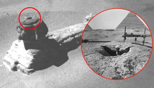 These rare photos reveal what the present is hiding from us: mysterious entrances into the world’s largest and oldest statue, the Great Sphinx of Giza. Probably the most famous monolithic monument on this planet, the Great Sphinx of Giza has been a constant source of fascination for those interested in our world’s past. It triggers the imagination and for that alone, the legacy of its mysterious builders is carried on. Mainstream archaeology claims the Sphinx was built in the 26th century B.C. during the reign of Pharaoh Khafre but many authors disagree with this theory. They are convinced the Sphinx is far older than the ancient Egyptians and as a result, the aura of mystery around the monument grows larger. If that is the case, who built it and for what purpose? Can we find evidence in support of these affirmations? Would it allow us to learn more about the ancient builders of the Great Sphinx? The Riddle of the Sphinx has been puzzling Egyptologists and amateurs alike ever since Europeans (re)discovered the Sphinx buried in sand. But it might surprise you to learn that even while covered up to its chest, the ancient statue was much more inclined to give up its secrets than it is today. 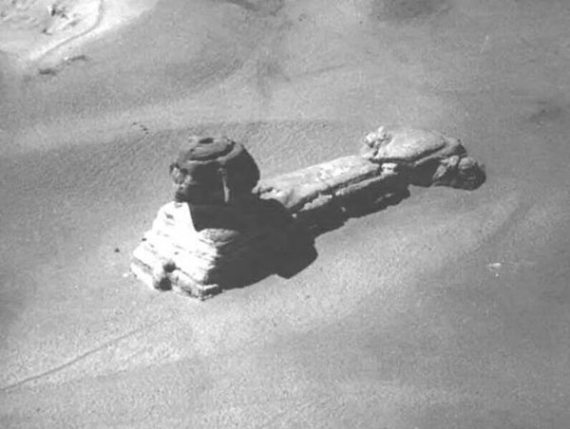 The photo above was taken from a hot air balloon sometime in the 18th century. Notice the opening at the top of its head? That opening is no longer visible today, so this is an instance when the cover-up is both literal and figurative. 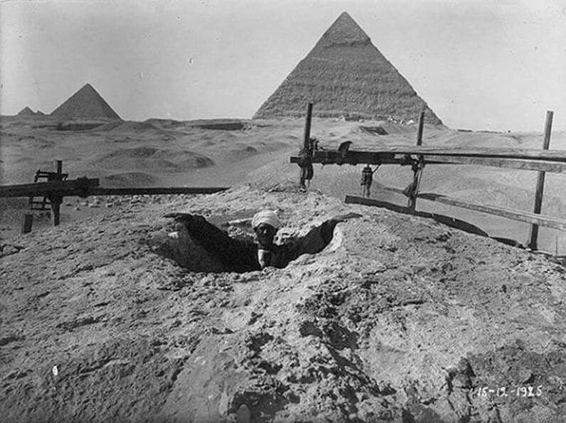 Early photos also show a large fissure accompanying an entrance located at the top of the Sphinx’s hips and many have surmised that opening led to a secret burial chamber. What you may or may not know is that the burial chamber was added to the Sphinx much later and might have no real value in the effort to find out the monument’s real story. Skeptics might say that the secret chambers of the Sphinx are actually an open secret and they are partially right. In the early 1800s, English Egyptologist Henry Salt reportedly entered the cavity beneath the altar of the Sphinx. 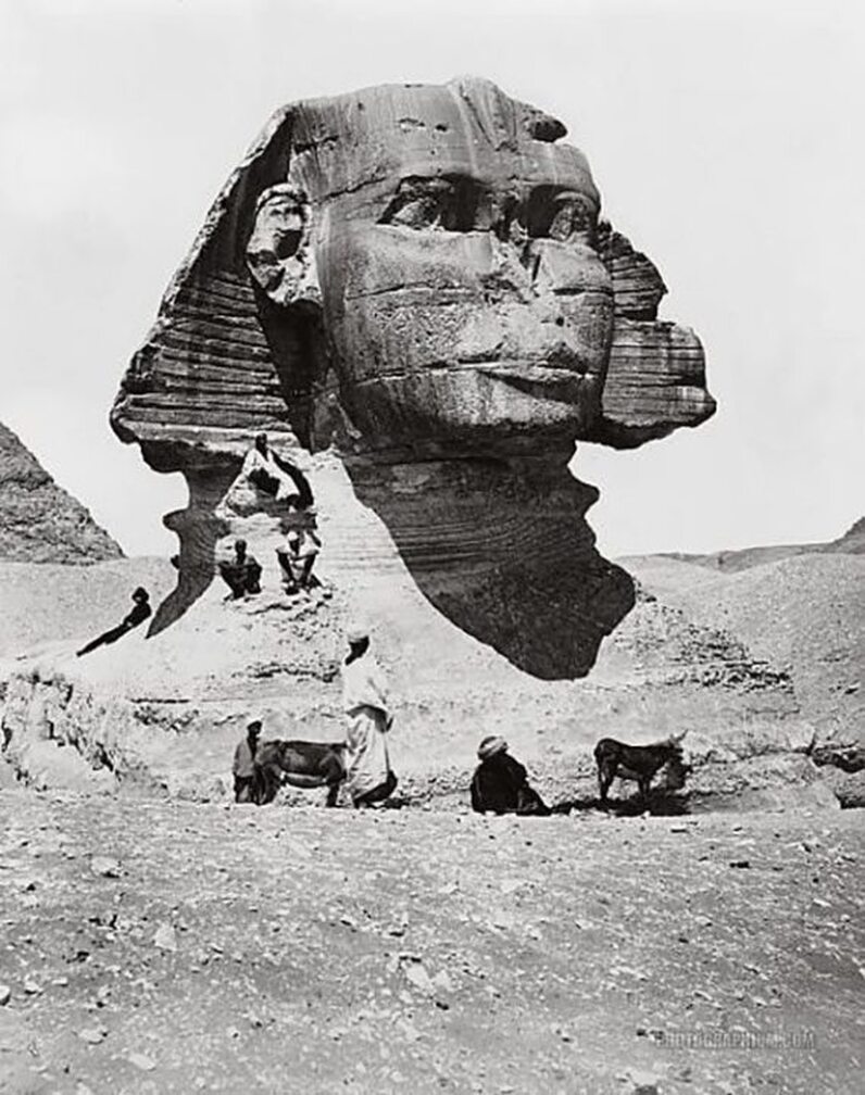 What he found there remains a mystery but what we do know is that he hastily sealed off the tunnel after a heated argument with his fellow explorer, the French antiquary LNP Auguste de Forbin. Another “restoration” that took place in 1926 involved several other secret entrances. The decision of French Egyptologist Émile Baraize to fill those entrances and the connected tunnels with cement has robbed future explorers of the chance to take a peek into this enigmatic masterpiece. And why should that matter? Because it might have something to do with humanity as a whole and if we’re to believe mystics and psychics, the Giza plateau could be home to the fabled Hall of Records. The mystery of this knowledge-containing chamber dates back to Pliny the Elder but according to some authors, it could be much, much older. It’s been claimed that the original builders of the Sphinx belonged to a superior race of highly-intelligent beings and that the secret chamber contains their accumulated knowledge circa 10.500 B.C. It is unclear whether this race could be linked to the survivors of the Atlantis cataclysm or was extraterrestrial altogether. Others propose that we will never find the Hall of Records, simply because this is not a physical place but rather a collection of thoughts and events encoded in the non-physical realm. Whatever the case may be, the mystery of the secret chambers beneath the Sphinx will maintain its allure over the human intellect. This is because our quest for knowledge about our origins, our creators is hardcoded into humanity’s collective journey. Enigmatic, unexplainable objects like the Holy Grail, the Ark of the Covenant, Atlantis, Shambhala and the Akashic records are checkpoints in our search for sacred knowledge and at the same time, keys that could unlock the truth about reality. While the Anunnaki were still celebrating the construction of the “artificial mounds”, Enki offered a suggestion to his brother, Enlil: “When in the future days it will be asked: when and by whom was this marvel fashioned?Let us beside the twin peaks a monument create, the Age of the Lion let it announce,The image of Ningishzidda [later known as Thoth], the peaks’ designer, let its face be,Let it precisely toward the Place of the Celestial Chariots gaze,When, by whom, and the purpose let it to future generations reveal!” 3 Ex-NASA Scientists Claim The Giant Face & Pyramid Found On Mars In 1976 Are Actually Real6/25/2021 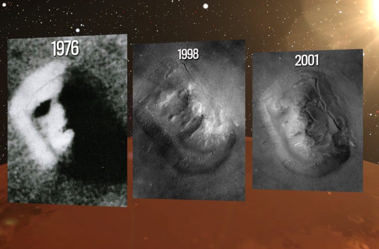 In 1976, the United States sent a pair of space probes, known as Viking 1 and Viking 2, to Mars. Viking 1 was launched on August 20th, 1975, and Viking 2 was launched in September of the same year. Both probes photographed the surface of Mars from orbit, and one studied the planet from the surface. The first one touched down on the surface of Mars on July 20th, 1976 and the second a couple of months later. The main objectives of the mission were to obtain high-resolution images of Mars, to look for any evidence of life, and to learn more about the structure and composition of the atmosphere. As Viking 1 spacecraft was circling the planet, it spotted the shadowy likeness of a human face. An enormous head nearly two miles from end to end seemed to be staring back at the cameras from a region of the Red Planet called Cydonia. A pyramid structure was also seen. This will be the main topic of this article. As a quick side note here, for years we’ve been made to believe that Mars is a dry and arid planet, completely devoid of life, but that’s just not the case. Mars actually used to be an Earth-like planet, with giant oceans and extensive greenery. The soil is moist and wet, and there is a very high likelihood that some type of life exists within the interior of Mars today. You can watch that full press conference below: The question to ask here is, did NASA know this information from the Viking data in 1976? According to multiple insiders who have worked for the agency, NASA is not always honest, and we are only being told this now because they believe we are ready to process and accept these facts. For example, Bob Dean, a retired United States Army Command Sergeant Major who also served at the Supreme Headquarters Allied Powers Europe (SHAPE) of NATO as an intelligence analyst, gave a lecture on footage and photos that had been erased and kept hidden for decades: Ladies and gentlemen, my government, NASA, which many of us in the United States say stands for Never A Straight Answer, proceeded to erase 40 rolls of film of the Apollo Program — the flight to the Moon, the flight around the Moon, the landings on the Moon, the walking guys here and there. They erased, for Christ’s sake, 40 rolls of film of those events. Now we’re talking about several thousand individual frames that were taken that the so-called authorities determined that you did not have a right to see. Oh, they were ‘disruptive,’ ‘socially unacceptable,’ ‘politically unacceptable.’ I’ve become furious. I’m a retired Command Sergeant Major. I was never famous for having a lot of patience. He is one of multiple people accusing NASA of doing this. The Russian government did the same last year. 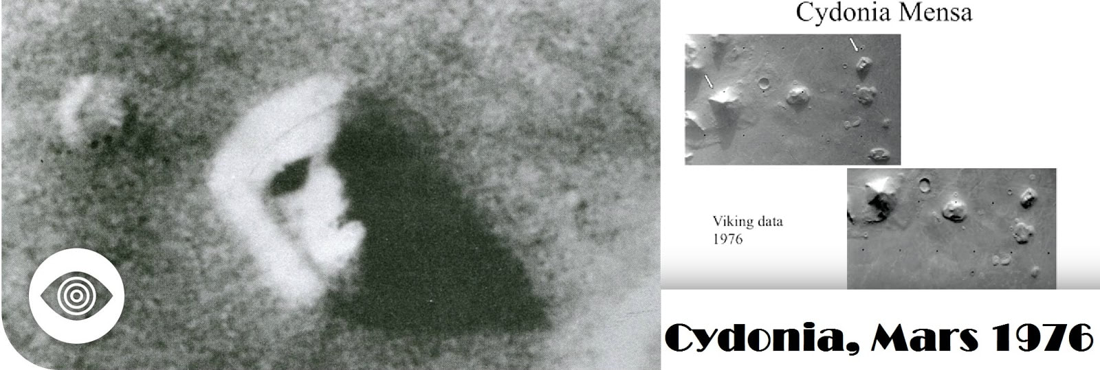 The Giant Face and Pyramid on Mars Above, you’ll see the original picture taken by Viking which, as you can imagine, created quite the buzz when the world got to see it. To the left, you can see a closeup of the face, as well as a pyramid in close proximity, taken by Viking. To the right, you will see the original picture taken by NASA, straight from their website in 1976. Above the picture to your left and right you will see three different images which, according to NASA, are clearer versions of the pictures taken with improved instruments. In their original caption of the picture, NASA described it as a “huge rock formation… which resembles a human head… formed by shadows giving the illusion of eyes, nose and mouth.” The authors reasoned it would be a good way to “engage the public and attract attention to Mars.” Well, according to multiple insiders with extensive backgrounds, this is not the case, and NASA lied about the images and data they collected, as well as fudged data and images. Based on these testimonies, among others, the photos released in 1998 and 2001 were meant to debunk rumours and put the issue to rest. The Scientists 1. Dr. John Brandenburg The picture above, which includes the pyramid, was taken from a lecture given by Dr. John Brandenburg (at the 26:46 mark). Any scientist who publicly shares information that challenges commonly held belief systems, as well as what’s been put out by mainstream media, will always come under public scrutiny and ridicule. But when you have worked on space plasma technologies, nuclear fusion, and advanced space propulsion, and invented the Microwave Electro-Thermal plasma thruster using water propellant for space propulsion, you deserve to be taken seriously. This is the case with Dr. John Brandenburg. He has also worked for the government with top-secret security clearances on various projects. He worked on the Rocket Plume Regolith Interactions on the Moon and Mars, Vortex theory of Rocket engine design, and the combined Sakharov-Kaluza-Klein theory of Field Unification for purposes of space propulsion and Mars science. Brandenburg was also the Deputy Manager of the Clementine Mission to the Moon, which was part of a joint space project between the Ballistic Missile Defence Organization (BMDO) and NASA. The mission discovered water at the Moon’s poles in 1994. (Source: page 16 of 18), (source), (source) He currently works as a consultant to Morningstar Applied Physics. Here is one of his latest research endeavours. Brandenburg also works as a part time instructor of astronomy, physics, and mathematics at Madison College, and other learning institutions in Madison, Wisconsin. Here’s what he had to say: “Someone complained to me, John, why do you have to bring Cydonia into this? And I said, because I can read a map… Here’s what’s at Cydonia Mensa. There’s the face on Mars, there’s the D & M pyramid… Here it is in a second shot, this was taken July 25th, this was taken 30 days later, the government was apparently doing a follow-up investigation. These two pictures (pictures above to your left) tell you everything you need to know about what’s at Cydonia Mensa (region of Mars). If you see on a planet that used to be Earth-like, a carved human face and a pyramid within 5 km of each other… it doesn’t take a rocket scientist to figure out what this all means, you can connect the dots… I mean sometimes, and I can tell you as a scientist and I’ve seen other scientists do this, if you’re cornered, you’re just brazing it out, you hold up a picture of a buffalo and insist that it’s a dog. You can watch his entire lecture, or read THIS article we recently published on it to get his main points. 2. Dr Brain O’Leary Dr. Brian O’Leary was a NASA astronaut, and a member of the sixth group of astronauts selected by NASA in 1967. After this, he was recruited by Carl Sagan to teach at Cornell University in the late 1960s, where he researched and lectured in the Department of Astronomy and Physics. After Cornell, he taught physics, astronomy, and science policy assessment at various academic institutions, including the University of California Berkeley, Hampshire College, and finishing off at Princeton University from 1976 to 1981. After that, he went on to Washington, where he would become an advisor to various political leaders, presidential candidates, and the United States Congress. O’Leary was also a member of the American Association for the Advancement of Science, as well as secretary of the American Geophysical Union’s Planetology Section. Furthermore, he was the team leader of the Asteroidal Resources Group for NASA’s Ames Summer Study on Space Settlements. He was a founding board member of the International Association for New Science as well as founding president of the New Energy Movement. O’Leary was always skeptical about Mars, and there are several others within these circles who were as well. I will be focusing on three. He had some interesting things to say during a live interview with Kerry Cassidy of Project Camelot (view full live interview here, read transcript of video here). O’Leary and Carl Sagan were close for a number of years, but had a falling out when O’Leary decided to leave Cornell. In the interview, he remarked: “It was… One very cold snowy day in May, I landed in Syracuse, and there was a horizontal blizzard — in May — and I said: That’s it for upstate New York. And Carl thought that was very frivolous. Because, of course, he was kind of an empire-builder kind of guy; and he also had a huge ego.” After he left, O’Leary started to examine some of Carl’s work. He said that the famous “Face” in Cydonia on Mars — photographed by Viking in 1975, this enormous formation (about a mile across) resembled a human face and created a major buzz at the time — was tampered with by Sagan before being released to the public: “It was very, very disappointing to me, because not only was Carl wrong, he also fudged data. He published a picture of the ‘Face’ in Parade Magazine, a popular article, saying that the ‘Face’ was just a natural formation, but he doctored the picture to make it not look like a face.” At this time, Sagan and O’Leary were arguably the world’s two leading experts on Mars, and they entered into many disagreements over that face. This rift was made clear in O’Leary’s publication in 1998, “Carl Sagan & I: On Opposite Sides of Mars.” It can be found in The Case for the Face: Scientists Examine the Evidence for Alien Artifacts on Mars, eds. Stanley V. McDaniel and Monica Rix Paxson. Kempton, IL: Adventures Unlimited Press. In May of 1990, O’Leary released a paper titled “Analysis of Images of the Face on Mars and Possible Intelligent Origin” which only further demonstrated his skepticism. It was published in the Journal of the British Interplanetary Society, Vol.43 No.5. O’Leary also went on the record and stated: I began to realize, just directly from the scientific point of view, not only hearsay, that this man was colluding with NASA, that there might be more to this than before… Carl was on a committee with a number of notable people. There was a report issued by the Brookings Institution in 1961 — and that’s about when I knew Carl, during those years; the ’60s mostly was when I worked closely with him — that he and this other group said: Well, if any ETs ever showed up on the Earth, it has to be covered up. That’s the only way we’re going to be able to manage this, because if we can’t, then it would be too much of a culture shock. Quite a shocking statement from someone of Brian’s stature, isn’t it? In the interview, he goes on to say that Carl and his colleagues recommended that the governments cover up the UFO phenomenon, and that he believes this provided justification for the ongoing coverup. When it comes to Mars, as mentioned earlier in the article, Sagan was a big debunker of the face, publishing multiple works stating that it was not a face, there were no pyramids, and that these are all the stuff of conspiracy theories. What’s interesting here is that not only does O’Leary mention Sagan and his relationship with him, but so does Dr. John Brandenburg. In the lecture he gave, cited earlier in the article, Brandenburg also mentions that he was in contact with Sagan, that he sent Sagan the images of Mars with an analysis of the Face and Pyramids, and that it was clear that that’s what they were. The response from Sagan to Brandenburg? “I never received them.” 3. Dr. Norman Burgrun A mechanical engineer, Dr. Bergrun has worked for Ames Research Laboratory, NACA (National Advisory Committee for Aeronautics), and Lockheed Missiles and Space Company, now known as Lockheed Martin. He then went on to found Bergrun Engineering and Research. Obviously, he is another qualified individual with an impressive background. You can view some of his publications for NASA, where he worked for more than a decade, here. In THIS interview, Bergrun accuses that agency of “garbling” photos and fudging data, as well as the face that was found in Mars in 1976. 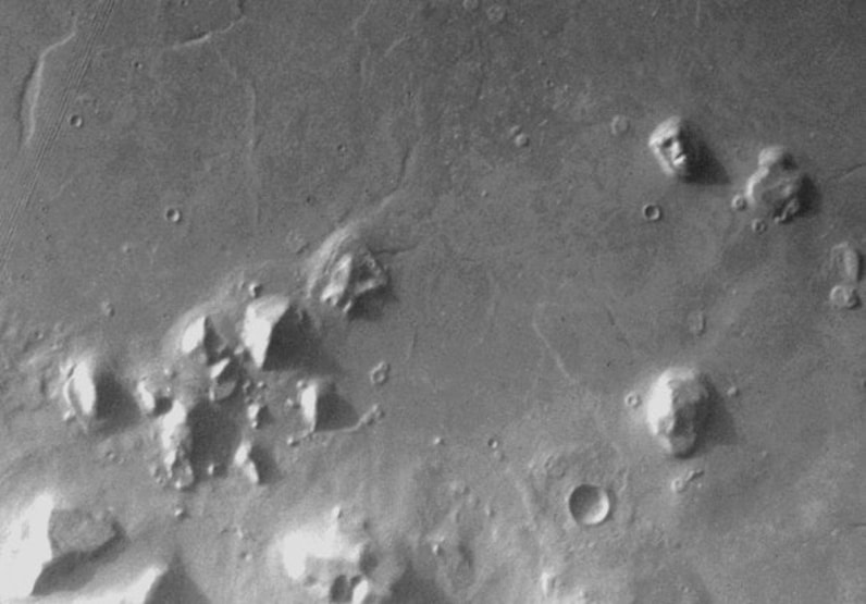 What Does This Tell Us and Why Is It Important? We live in an age where more and more people are waking up to the secrecy that plagues our planet. Ten years ago, if you were to mention that we are being ‘watched’ through various high tech means, it would have been unbelievable, but thanks to people like Edward Snowden, we know this to be true. It’s unfortunate to realize that so many facts about our world are kept hidden from us, supposedly for the sake of ‘national security,’ but it’s quite evident that there are also special interests at stake, and secrecy is used to preserve and uphold these interests, whatever they may be. Today we have many whistleblowers with verified credentials from various agencies and branches of government who are spilling the beans on several different topics, as well as other evidence to corroborate and back up what the say. Our website is full of examples; the ones presented in this article represent just a select few. While witness testimony is not always deemed credible, when you have up to, arguably, more than one thousand qualified people coming forward, it becomes difficult to ignore. Today, in 2016, it’s important to keep an open mind, because information will keep emerging that threatens the belief systems of many. Too often we completely shut down any chance of even entertaining this type of information, and that’s done out of fear. When we’ve been shielded from the truth for so long it can indeed be scary, and sometimes downright unbelievable, to wake up to the truth. Secrecy is a great way for the establishment to keep us in line and prevent the human race from growing, expanding, and exploring, but our consciousness is shifting. We are becoming more aware, more curious, and more passionate about creating a better human experience for the entire race. We are constantly distracted with our own lives, trying to put food on the table and make it through another work week, having our minds, thoughts, and wants programmed into our brains through mass marketing, but many people are no longer resonating with this type of human experience. It’s time to start asking the bigger questions. It’s time for the human race to leave its infancy and grow into adulthood, and transparency is the first step. Proper progress cannot be made if a civilization tries to move forward blindly, unconscious of the true nature of reality. “The image of Alalu upon the great rock mountain, with beams they carved. They showed him wearing an Eagle’s helmet (astronaut helmet); his face they made uncovered. “Let the image of Alalu forever gaze toward Nibiru that he ruled, toward the Earth whose gold he discovered! So Ninmah, in the name of her father Anu did declare.” — Read the whole story here. According To This Map, The Ancients Used To Transit The Entire World Using Advanced Technology6/24/2021  Various ancient maps discovered throughout time reveal a slightly different reality than what we’ve been accustomed to, with the most astounding find being the continent of Antarctica, mapped by the ancients at a time when this southernmost landmass was free of ice. Since birth, people are hard-wired to adhere to a dogmatic reality with a narrow view of the world. As time passes, evidence contradicting this paradigm is brought to our attention, and so we rapidly adjust our way of thinking to a bigger picture that doesn’t appear to be framed, nor acknowledged by modern understanding. One of the most substantial examples is that of ancient sailors who were apparently able to traverse the planet from one pole to another. These people had advanced knowledge in many fields, and were able to produce precise charts of the world using an instrument of navigation for accurately determining longitudes that was beyond anything possessed by either of the ancient, medieval, or modern people up until the 18th century. Because of this evidence that cannot be in any way hindered or disproved, we can assume that a long-forgotten civilization thrived on this earth in remote times. Evidence is mounting in this direction, and those who reject this hypothesis as mere myth will soon have to rethink and redesign the entire concept of human history. Among the many paradigm contradicting pieces is the Oronteus Finaeus map. Published in 1531, it displays Antarctica free of ice, together with accurate depictions of rivers, valleys, coastlines, and the approximate location of the south pole. It also gives the appropriate longitudinal coordinates. Keep in mind that Antarctica was barely discovered (at least by modern standards) in 1773, after Captain James Cook and his crew reached the islands of the Antarctic Circle, but none set foot on the actual landmass until the Norwegian expedition in 1911. 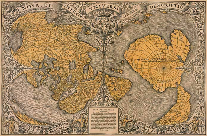 This could mean two things. Either the presented map is an elaborate forgery, and as you’re about to see this comes out of the question, or human beings are once again rediscovering a land and knowledge that was once lost to the infamy of time. This, in turn, adds to a greater pile of ‘controversial’ evidence that hints at the very same thing – the existence of an advanced civilization before or during the last ice age. The highlighted world-map was drawn by Oronteus Finaeus in 1531. It compiled various source maps that made it out of the great library of Alexandria during the ruthless siege of Egypt. Those sources originated from a peoples unknown that allegedly passed down the information from one generation to another. Egyptian cartographers who studied that information made various charts that were transferred to Constantinopole and other cultural centers after the siege of Alexandria. The maps were stored there until 1204 when, during the Fourth Crusade, Venetians besieged Constantinopole and numerous valuable resources fell into their hands. Since then, the charts made it into circulation because they showed never before reached areas such as the Americas, Arctic and Antarctic seas. Charles Hapgood, an esteemed American writer and professor, came across the intriguing chart during his early studies in the 90s. After devoting a great deal of time analyzing it, he reached the aforementioned conclusions. Although the scientific community couldn’t agree with his paradigm-shattering finds, he carried on with his investigation that eventually yielded the expected results. Here is an excerpt from his work on the Oronteus Finaeus map. The general shape of the continent was startlingly like the outline of the continent on our modern map. The position of the South Pole, nearly in the center of the continent, seemed about right. The mountain ranges that skirted the coasts suggested the numerous ranges that have been discovered in Antarctica in recent years. 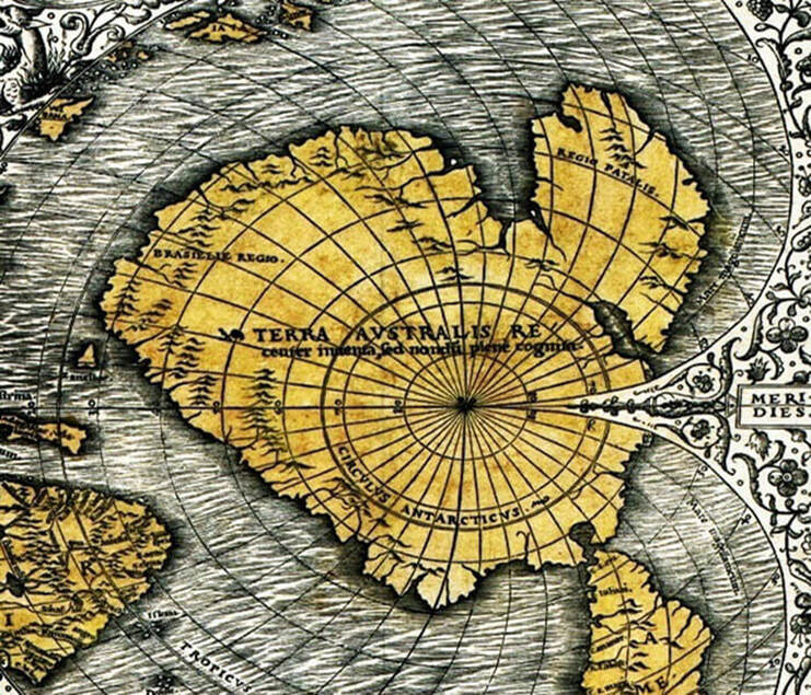 It was obvious, too, that this was no slapdash creation of somebody’s imagination. The mountain ranges were individualized, some definitely coastal and some not. From most of them rivers were shown flowing into the sea, following in every case what looked like very very natural and very convincing drainage patterns. This suggested, of course, that the coasts may have been ice-free when the original map was drawn.” In 1960, Professor Hapgood delivered his findings to the US Air Force which performed a thorough analysis of both the Oronteus Finaeus map and the Piri Rei’s map of the Turkish Admiral. In 1961, he received a response that would please him and further confirm his beliefs, although the rooted conceptions of the scientific community remained unchanged. Nevertheless, the idea of a timeworn and ‘modern’ civilization that existed before our current timeline transformed into a solid pillar, hard, if not impossible to crack. The below transcript received by Professor Hapgood from the US Air Force investigation team represents the culminating point of this investigation due to its official nature. 8 RECONNAISSANCE TECHNICAL SQUADRON – (SAC) UNITED STATES AIR FORCE Westover Air Force Base, Mass. 14 Aug 61 Mr. Charles H. Hapgood Keene Teachers College Keene, N.H. Dear Professor Hapgood: It is not very often that we have an opportunity to evaluate maps of ancient origin. The Piri Reis (1513) and Oronteus Fineaus [sic] (1531) maps sent to us by you, presented a delightful challenge, for it was not readily conceivable that they could be so accurate without being forged. With added enthusiasm we accepted this challenge and have expended many off duty hours evaluating your manuscript and the above maps. I am sure you will be pleased to know we have concluded that both of these maps were compiled from accurate original source maps, irrespective of dates. The following is a brief summary of our findings: A. The solution of the portolano projection used by Admiral Piri Reis, developed by your class in Anthropology, must be very nearly correct; for when known geographical locations are checked in relationship to the grid computed by Mr. Richard W. Strachan (MIT), there is remarkably close agreement. Piri Reis’ use of the portolano projection (centered on Syene, Egypt) was an excellent choice, for it is a developable surface that would permit the relative size and shape of the earth (at that latitude) to be retained. It is our opinion that those who compiled the original map had an excellent knowledge of the continents covered by this map. B. As stated by Colonel Harold Z. Ohlmeyer in his letter (July 6, 1960) to you, the Princess Martha Coast of Queen Maud Laud, Antarctica, appears to be truly represented on the southern sector of the Piri Reis map. The agreement of the Piri Reis Map with the seismic profile of this area made by the Norwegian-British-Swedish Expedition of 1949, supported by your solution of the grid, places beyond a reasonable doubt the conclusion that the original source maps must have been made before the present Antarctic ice cap covered the Queen Maud Land coasts. C. It is our opinion that the accuracy of the cartographic features shown in the Oronteus Fineaus [sic] Map (1531) suggests, beyond a doubt, that it also was compiled from accurate source maps of Antarctica, but in this case of the entire continent. Close examination has proved the original source maps must have been compiled at a time when the land mass and inland waterways of the continent were relatively free of ice. This conclusion is further supported by a comparison of the Oronteus Fineaus [sic] Map with the results obtained by International Geophysical Year teams in their measurements of the subglacial topography. The comparison also suggests that the original source maps (compiled in remote antiquity) were prepared when Antarctica was presumably free of ice. The Cordiform Projection used by Oronteus Fineaus [sic] suggests the use of advanced mathematics. Further, the shape given to the Antarctic continent suggests the possibility, if not the probability, that the original source maps were compiled on a stereographic or gnomic type of projection (involving the use of spherical trigonometry). D. We are convinced that the findings made by you and your associates are valid, and that they raise extremely important questions affecting geology and ancient history, questions which certainly require further investigation. We thank you for extending us the opportunity to have participated in the study of these maps. The following officers and airmen volunteered their time to assist Captain Lorenzo W. Burroughs in this evaluation: Captain Richard E. Covault, CWO Howard D. Minor, MSgt Clifton M. Dover, MSgt David C. Carter, TSgt James H. Hood, SSgt James L. Carroll, and A1C Don R. Vance. LORENZO W. BURROUGHS Captain, USAF Chief, Cartographic Section 8th Reconnaissance Technical Sqdn (SAC) Westover Air Force Base, Massachusetts The above transcript is not the sole piece of official evidence gathered in support of his claims. Professor Hapgood received other fascinating letters from MIT, and Cambridge university, as well as other correspondence between the Turkish embassy and the US State Department. More ancient and mysterious maps are presented in his book written in 1966 – Maps of the Ancient Sea Kings. 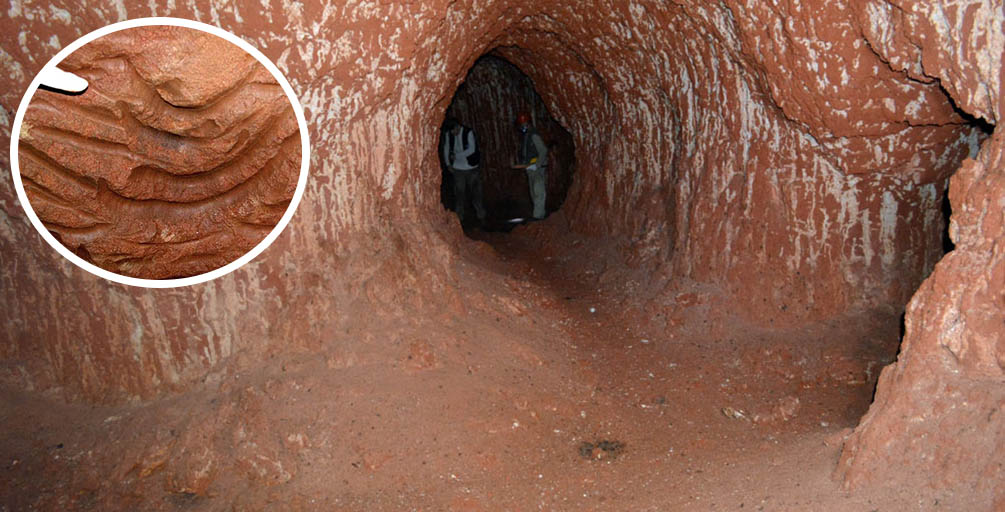 Hundreds of tunnels — which date back at least 10,000 years — have been discovered in Brazil. Some of the tunnels feature mysterious claw marks’ on the walls. “There’s no geological process in the world that produces long tunnels with a circular or elliptical cross-section, which branch and rise and fall, with claw marks on the walls,” says a geologist. “I’ve [also] seen dozens of caves that have inorganic origins, and in these cases, it’s very clear that digging animals had no role in their creation.” Experts in Brazil have discovered hundreds of underground tunnels which date back over 10,000 years. Interestingly, experts believe that these mysterious tunnels were NOT carved by humans, but by an extinct ancient species. The discovery was made by Heinrich Theodor Frank, a geologist at the Federal University of Rio Grande do Sul — one of the largest federal universities in Brazil. As Heinrich was driving on the national Novo Hamburgo highway, he noticed a strange hole of around one meter in diameter at a construction site which caught his attention. Since he was in a hurry to get home, he did not stop. However, a few weeks later he went back to the same place with his family, where he stopped and asked them to wait a moment in the car while he investigated the tunnels. “I noticed that it was a tunnel, about 70 centimeters high and a few meters in length. The interior was full of scratches,” explains Theodor Frank to National Geographic. “When I got home I looked for an explanation on the internet, but I did not find anything.” “Since then I have heard that the tunnels are huge anthills or that they were created by Indians, Jesuits, slaves, revolutionaries and even bears. Some even talk about a great mythological serpent, which dug the tunnels,” he says. 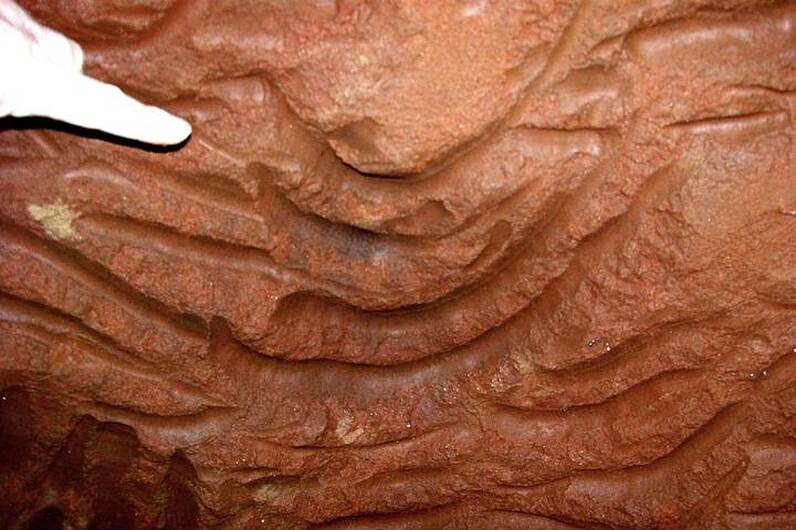 Trying to get to the bottom of the mystery, Theodor Frank eventually sent some photographs to Marcelo Rasteiro, a member of the Brazilian Society of Speleology, who responded by sending an article about paleoburrows, tunnels excavated by any type of living organism in any geological age. “For example a worm in the Cambrian, a mollusk in the Mesozoic or a rat in the Pleistocene.” “I didn’t know there was such a thing as paleoburrows,” says Frank. “I’m a geologist, a professor, and I’d never even heard of them.” So who could have dug those terrifying labyrinthine tunnels, with their walls covered with scratches? “When you explore the burrows you sometimes have the feeling that there is a creature waiting for you after the next curve as if it were the lair of a prehistoric animal,” says Frank in an article published by Discovery. Certainly, these tunnels were not created by the natives of Brazil. “The Indians who lived in Brazil before the arrival of the Europeans did not know about the existence of iron and therefore had no tools to dig through the hard rocks in which these tunnels are dug,” explains National Geographic.  Curiously, there are hundreds of these tunnels all over Brazil, although many Curiouslyletely filled with sediment that accumulated after the tunnels were abandoned, but the entries are still distinguished in a circular or elliptical form. Geologist Amilcar Adamy of the Brazilian Geological Survey has confirmed the discovery of a large complex of 600-meter-long tunnels in the state of Rondonia. Furthermore, Frank notes that “in neighboring countries such as Uruguay, Paraguay, Chile and Bolivia we have detected a few caves that could also be paleoburrows. In Argentina, there are many of them, mainly in the cliffs of the Atlantic coast, in Mar del Plata.” As noted by Alfredo Carpineti from IFLScience, over 2,000 burrows have been found, including one just last Wednesday. Scientists believe they were dug between 10,000 and 8,000 years ago, although researchers are yet to properly date them. Frank says that speleothems, or mineral deposits, growing on burrow walls could be used to calculate an age, although that hasn’t been tried yet either.  Giant Armadillos? Mega-Sloths? “The biggest giant armadillo had a body width of 80 centimeters, while the tunnels reach widths of 1.4 meters and in addition, the ceiling is full of scratches “I personally believe they were excavated by land sloths, a group of mammals that became extinct in that area about 10,000 years ago,” says Frank. “There are large tunnels up to two meters high and four meters wide that were undoubtedly excavated by sloths. We do not know the specific species, but surely the largest ones (megatheriums and eremoterios) were too large to dig,” he added. “We also do not know what the function of the paleoburrows is, perhaps the climate is an explanation: it was drier and hotter than today and the tunnels were isothermal, but this can hardly explain the complex system of tunnels several hundred meters long, which were most likely inhabited by groups of sloths or armadillos. “The roofs and walls of many tunnels are polished, probably thanks to the friction of the animals’ fur, which moved through the tunnels for decades or even centuries,” concluded Frank. “So if a 90-pound animal living today digs a 16-inch by 20-foot borrow, what would dig one five feet wide and 250 feet long?” asks Frank. “There’s no explanation – not predators, not climate, not humidity. I really don’t know.” However, as noted by Discovery, another mystery is the strange geographic distribution of the tunnels. The so-called paleoburrows are common in southern parts of Brazil, in the states of Rio Grande do Sul and Santa Catarina, they are, so far, almost unknown just to the south in Uruguay. Furthermore, experts note that very few of them have been discovered in northern parts of Brazil, and only a handful of possible burrows have been found in other South American countries. 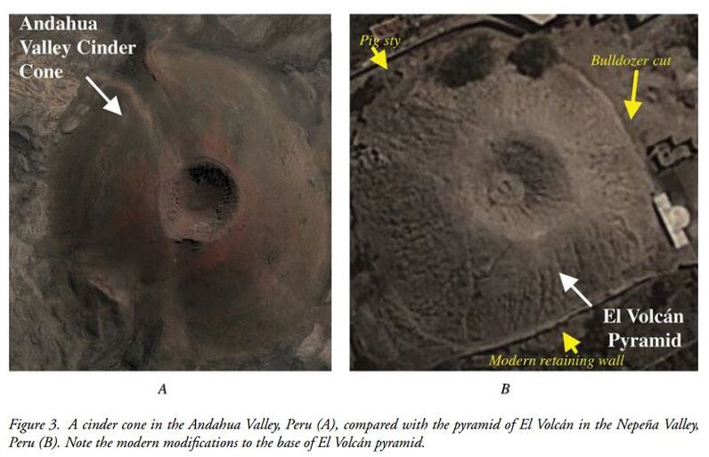 A group of archaeologists has carried out a new investigation of a pyramidal structure known as “El Volcán” in the valley of Nepeña in Peru. Ever since its discovery, archaeologists have been left perplexed by the structure and its mysterious shape, modeled in ancient times to mimic the form of a Volcano. It should be noted, however, that there are no volcanoes in the vicinity of El Volcán to serve as models, nor indeed are any other examples of volcano-shaped structures known from Peru or elsewhere. In order to understand more about the enigmatic Pyramid, a team led by emeritus professor of the University of Missouri (USA), Robert Benfer, has investigated the construction discovered in the 1960s and published a study in the journal Antiquity. The structure known as ‘El Volcan’ has a height of 15.5 meters, with an inner “crater”, similar to that of a volcano. Scientists excavated a ditch in the volcano crater and discovered a collapsed ladder that descends under a layer of adobe to a plaster and mud floor – and a hearth containing charcoal and shell. Furthermore, thanks to radiocarbon dating experts were able to reveal the unusual occurrence of four total solar eclipses at the site over the span of just 11 years, an indicator that the structure may have been used to celebrate the victory of the moon over the sun indicates the Daily Mail. According to data published in the Journal Antiquity, it is not known exactly when the structure was built, but its proximity to the late Formative center of San isidro—between 900BC-200BC—suggests that there may be a link to this period. The authors of the study wrote: “The date at which the pyramid was first constructed is currently unknown, although the site’s proximity to the Late Formative Center (900 BC–200 BC) of San Isidrio (Chicoine & Ikehara 2014) is suggestive. “Surface ceramics from San Isidrio resemble some of those found at El Volcán, but these lack context and may have been imported to the site with soil from nearby areas.” 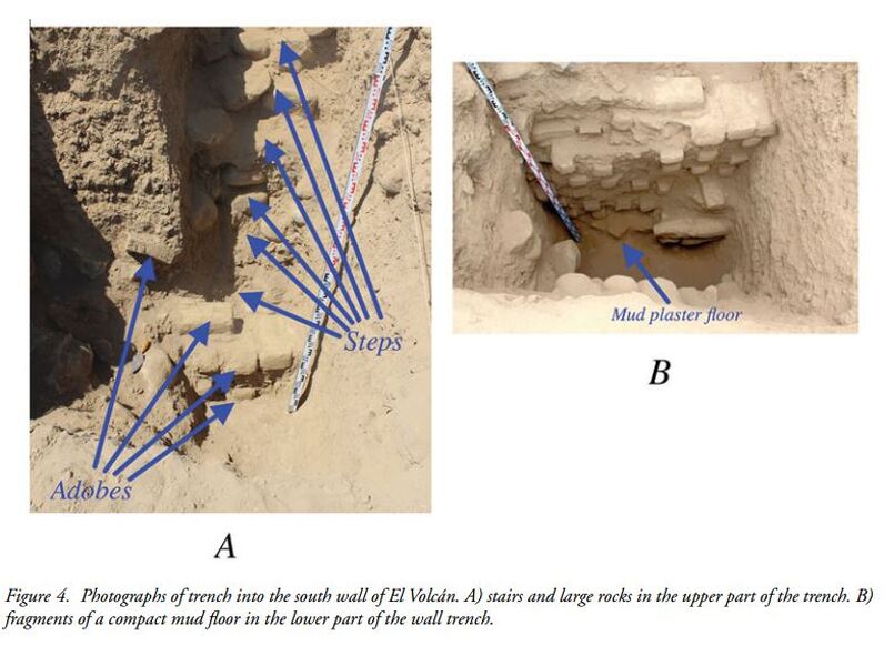 While the pyramid isn’t that tall—comapred to other structures in Central and South America, the strange crater-like feature of this pyramids makes its unique. Ever since it was discovered, archaeologists and experts have been left baffled by the enigmatic structure. In the new study authors wrote: “When viewed from a distance, the site resembles a volcanic cinder cone, such as the one in the Andahua Valley in southern Peru and we have therefore named the site El Volcán. “It should be noted, however, that there are no volcanoes in the vicinity of El Volcán to serve as models, nor indeed are any other examples of volcano-shaped structures known from Peru or elsewhere.” At this early stage of the investigation, the El Volcán site presents a conundrum. The unusual shape of the pyramid merits note, but it is not obvious what might have prompted its construction or what activities might have taken place there. Two main explanations have been put forward, one arguing that later looting or erosion has created the site’s distinctive form and the other that the site was originally constructed to resemble a volcanic cone and can be linked to astronomical events and ethnohistorical accounts. Experts concluded—based on present evidence—that the pyramid was originally and deliberately constructed in the form of a volcano—a cone-shaped pyramid with a central pit. 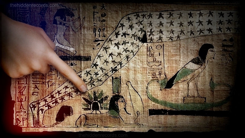 The God Ra of the ancient Egyptians is said to have sailed down from the stars and landed in Egypt, founding a powerful civilization. This is all very well but was it some misconstrued myth or could there be some grain of truth to this obsession. A 3000 year-old vignette from the Djedkhonsuiefankh funerary papyrus on display in the Cairo Museum shows exactly how Ra’s ship appeared to the earliest scribes who created the papyrus. It looks nothing like the traditional boat seen in other later depictions and it looks exactly like something important the ancient Egyptians passionately describe in their texts: A disc that flies and radiates bright light! 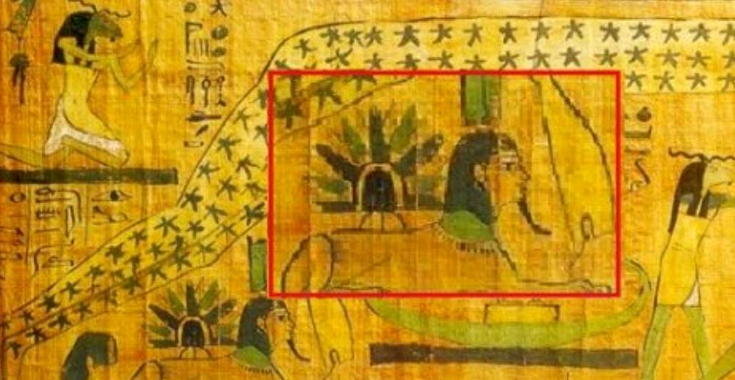 Wayne Herschel South African author of a book titled The Hidden Records which offers a completely new hypothesis explaining the star god veneration of ancient civilizations insists this depiction is the secret behind the iconic winged disc of Egypt. He supports many other controversial authors who have suggested that the strange winged disc of Egypt really is an ancient UFO. But believes this is the missing piece of the puzzle that proves it. He says the anomaly on the papyrus is clearly celebrating exactly what it is, a flying disc that shines like the sun and comes from the stars. 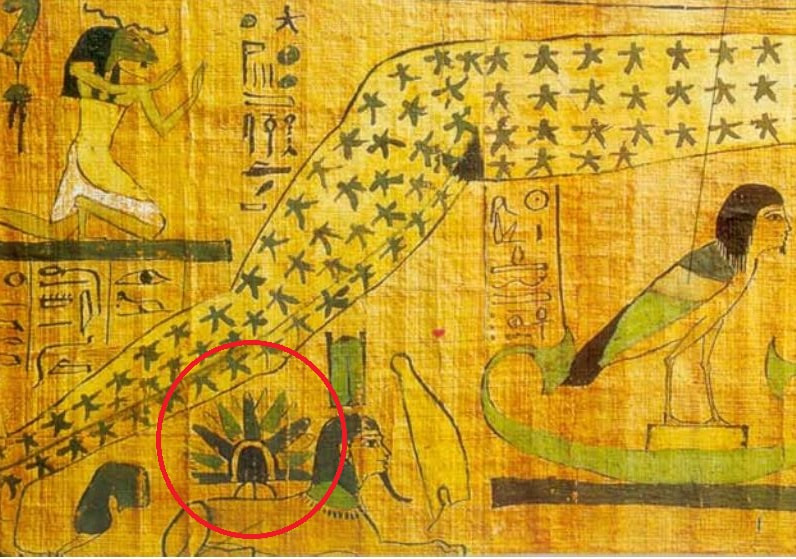 Wayne Herschel suggests there is a lot more evidence to reason here. It is not only a flying disc arriving from the stars, but the papyrus also shows the constellation that is closest to the specific star of Ra with other forgotten symbols. There is a lot more here. He says another very important issue here in the scenario portrayed in the vignette is where the disc landed. It is shown positioned on what can only be the Sphinx of Egypt with what he insists is its full undeniable pictographic title. It also suggests the place of the legendary Hall of records! It shouts out convincingly in context with everything else here that its a real ship from the heavens in typical UFO style landing on the famous Sphinx monument and its on a recorded on an ancient Egyptian papyrus! “It is a disc with a dome radiating coloured bright light… and it is poised on three legs like a tripod. No wonder the back of the Sphinx was flat. Wayne Herschel claims there is also a tomb that clearly depicts the Sphinx with a lion’s head, something completely missed by historians and authors alike. “There are remnants of what appears to be the remains of an arched door that is now filled in from many repairs over thousands of years and its visible at the back of the Sphinx’s head!” Deciphering the true meaning of this papyrus has been the subject of debate among scholars for years. It is still explained away as a cult like strange belief system and is still a mystery. Firstly, ancient Egypt has at least five different interpretations of the genesis pictoglyphs to start with, so even the ancients had forgotten most of its meaning. Wayne Herschel proposes a whole collection of supporting evidence and carefully presents this in a two-part video [below]. With such a controversial claim, every minute detail needs to be seen for its merit. Wayne Herschel’s book The Hidden Records, which challenges the fundamentals in archaeoastronomy like never before, previously identified a stellar pattern that is reproduced in the founding monuments of just about every Megalithic ancient civilization. Since the book, with the theory that the star of the “gods” is identified in a precise position near a cluster of stars called the Pleiades, he sets out to prove another 16 or so civilisations across the globe showed exactly the same records. “Virtually all ancient civilisations obsessed in star gods with their beginnings. Many went on to build massive monuments to mark the stars positions on the ground and virtually all choosing the same ‘x’ that marks the spot as their ultimate monument within the specific star pattern.” Astronomers have desisted from commenting after realising the patterns speak for themselves. But what is even more daunting for scholars is that if these patterns so meticulously laid out by the ancients on the ground are indeed venerating a very specific area in the night sky. Wayne believes in his conclusion it presents a very powerful case for our human ancestors having originating from the stars. “The 3000 year old papyrus has everything I was looking for… the cosmic address of the ultimate Sun God “Ra”, what his celestial ship looked like, and where it landed… all this in a well known Genesis portrayal of the beginnings of ancient Egypt.” “The papyrus has the typical Egyptian portrayal of the sacred feminine (already popularised by Dan Brown) and the seeding of the sky goddess Nut by Geb. I have produced animations and detailed artefacts and murals that tell the story in a simple way. But be warned, the ancient Egyptians were very sexually explicit in their portrayal of the human genesis. But history is history and the meaning of this papyrus challenges everything in Egyptology from ground zero. The ancients certainly did not lie about their star gods. These gods appear to be very real, not just to the Egyptians but all ancient civilizations. It explains why so many venerated the cosmic bull, it was Taurus. Infinitely more important, Wayne Herschel challenges Egyptologists … They worshiped a SUN… BUT it was not OUR sun at all! This story is deciphered and referenced in the videos below. |


Ufomania Store
Helena MatiasEditor 
Please visit and subscribe our youtube channel
Archives
July 2024
Please take a look below at the amazing work of Author and researcher Stephen Quayle
Categories
All
|