The TikTok posted by @carlosruizoficial has since gone viral with a staggering 10.8 million views. The clip shows a man preparing for his typical training session in a gym with nothing out-of-the-ordinary in shot.
Things initially appear normal – that is, until gym objects start moving unexplainably. The apparatus in the back begins to swing and a weighted medicine ball rolls towards the man, all by itself.
0 Comments
 In 1943, German Navy Grand Admiral Karl Doenitz stated that the German submarine fleet had “built for the Führer an impregnable fortress at the other end of the world,” in the region of Queen Maude’s Land, Antarctica, later renamed Neuschwabenland. According to German naval archives, two months after Germany surrendered to the Allies in April, 1945, the German submarine U-530 left the Port of Kiel bound for Antarctica. Once the submarine arrived at the South Pole, 16 members of its crew were ordered to construct an ice cave in the region of Neuschwabenland. The German U-boat then entered the Argentinean port of Mar-del-Plata and surrendered to authorities. In August, 1945, one month and seven days after the surrender of U-530, U-977 also entered the waters of Mar-del-Plata and surrendered to authorities. In 1946, Operation Highjump commenced as part of the U.S. Naval Antarctic Developments Project, organized by Secretary of the Navy James Forrestal. The task force consisted of over 40 ships, including two destroyer class vessels and the aircraft carrier the U.S.S. Philippine Sea, and a number of planes that were outfitted with a trimetricon (a secret spying camera), a magnetometer (to record any magnetic anomalies), and the recently developed jet-assist takeoff bottles (JATO) which helped with takeoffs from the short runway on an aircraft carrier or for takeoffs on hard ice. It has been long thought by researchers that the Navy’s mapping story was nothing more than a cover to shield the real operation. They were looking for the underground Nazi base (Base-211) that warehoused German Vril flying discs known as flugscheiben and Thule mercury-powered spaceship prototypes also known as jenseitsflugmaschines. 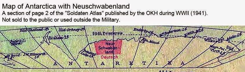 In 1947, Admiral Richard Byrd said: “the project was necessary for the USA to take defensive actions against enemy fighters which come from the polar regions.” Was he referring to potential Soviet aircraft or Nazi Luftwaffe attacking the States from Antarctica? He never clarified. Shortly after Admiral Byrd’s press conference the Soviet naval journal, Red Fleet, stated that: “US measures in Antarctica testify that American military circles are seeking to subject the Polar Regions to control and create permanent bases for their armed forces.” In another odd twist, the governments of New Zealand, Australia and Chile asked for their militaries to join the Operation Highjump expedition but were denied participation. In 1948, a second task force named Operation Windmill was also sent to take photographs of Neuschwabenland, again supposedly for mapping purposes. Although they apparently succeeded in their task, the government has yet to make these photos available to the public and no reason has ever been given for their nondisclosure.  Some believe that the reason the photos have never been released is that this military operation was actually a reconnaissance and recovery mission. In 1949 Secretary of Defense James Forrestal, a close friend of Admiral Byrd, was sent to stay at Bethesda Naval Hospital. He began to discuss Operation Highjump with the hospital staff, talking wildly about UFOs, Atlantis, and an underground Nazi city. He was denied visitors, including his wife, and shortly afterwards “fell” out of his hospital window to his death. 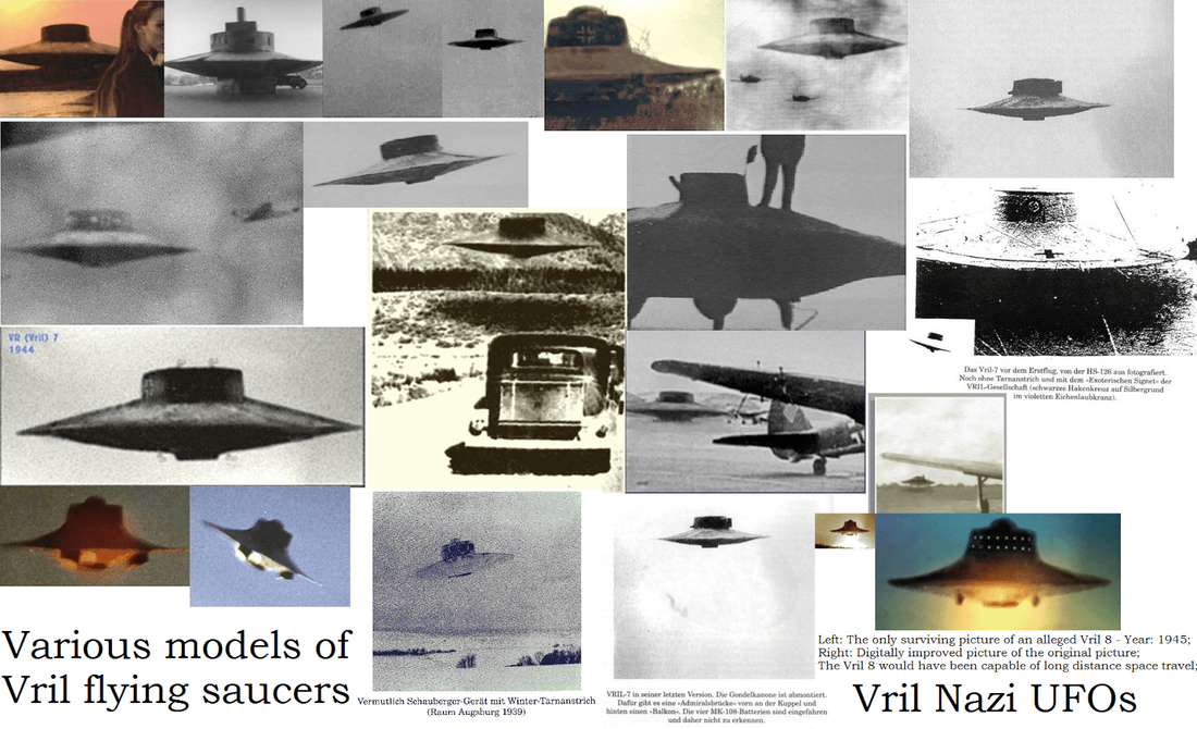 Actual pictures of Vril flying saucers The official report said that he committed suicide but persistent rumors say that he was murdered by government agents to keep him from talking further about what was really found in the Antarctica wilderness during Operation Highjump. The entire truth of the matter may never come to light, but what is known is that numerous U.S. military personnel surprisingly lost their lives during Operation Highjump; a supposed mapping operation that should have been an entirely safe endeavor. Also, multiple planes were downed during the operation, including the George One which, according to Naval documents, mysteriously “just blew up” over the ice during its initial flight in Antarctica. According to British Intelligence, we know that advanced, stealth foo fighters and Vril flying saucer-shaped craft were developed and tested at the German Institute for Aerial Development.  Another motive associated with Nazi involvement in Antarctica is that it was rumored to be the entrance to the lost Aryan homeland of Thule. While Antarctica has been linked to the lost continent of Atlantis, the linkage to Thule is less apparent. Thule (also known as Thula, Thyle, Thila, Tila, Tyle, or Tylen, among other cognates) was first written about by the Greek explorer Pytheas after his travels between 330 BC and 320 BC. In 150 AD, Greek writer Antonius Diogenes wrote The Wonders Beyond Thule. While of literary interest, this work did little to reveal any secrets about Thule. In medieval geographies Thule was referred to as distant place located beyond the “borders of the known world.” Occult mystics believe in historical Thule (also referred to as Hyperborea) as the ancient origin of the Aryan race. Just what was the US military doing in Antarctica in 1946 and 1947? Were they on a routine mapping mission or were they engaging remnant Nazi fighters with advanced alternative technology? Did the Nazis truly build a military base in the Antarctic or hide vast amounts of gold there in hopes of funding a future effort to resurrect the Fourth Reich? Or did they, as some claim, discover the lost land of Atlantis or Thule? We may never know for sure, but in 2001 the U.S. National Geospatial-Intelligence Agency and the Support Office for Aero-geophysical Research confirmed the existence of a magnetic anomaly on the eastside shore of Lake Vostok in Antarctica, consistent with a man-made construct. More recently, in October 2006, the Scripps Institute of Oceanography reported that they discovered several previously unknown lakes of water underneath the vast ice sheet of Antarctica. These lakes lie beneath 2,300 feet of compressed snow and ice. Could this anomaly be part of an underground Nazi base that U.S. agents searched for during Operation Highjump? Something has indeed been discovered in Antarctica. One of the questions that begs to be asked is did the Nazis find, whatever it is, first? A book published in 1978, called Secret Nazi Polar Expeditions, relates how the Germans had taken a ship with a small airplane on it that they launched from their ship after reaching the ice near Antarctica. It flew over the ice to Antarctica, presumably on a scouting flight, and then back to the ship. But the book didn’t say anything about what it supposedly found or what the Nazi party elite believed was an entrance to the inner (hollow) earth. An interesting document has recently surfaced obtained by a Joe Watson of Talkeetna, Alaska. Mr. Watson claims it is a copy of a letter written on 2 March 1985 in the German language from a German submarine crewman who was on board. In it is given certain coordinates for their mission, which apparently was to travel to the center of the earth. Their submarine was called U-209 under Captain Heinrich Brodda. The image below is a copy of the original hand-written letter from Karl Unger, crew member of the German U-209, as well as an English translation (click to enlarge). In it Karl confirmed that the earth was indeed hollow and that they had successfully reached the inner inhabited earth in the German U-209 submarine after World War II had destroyed Germany. 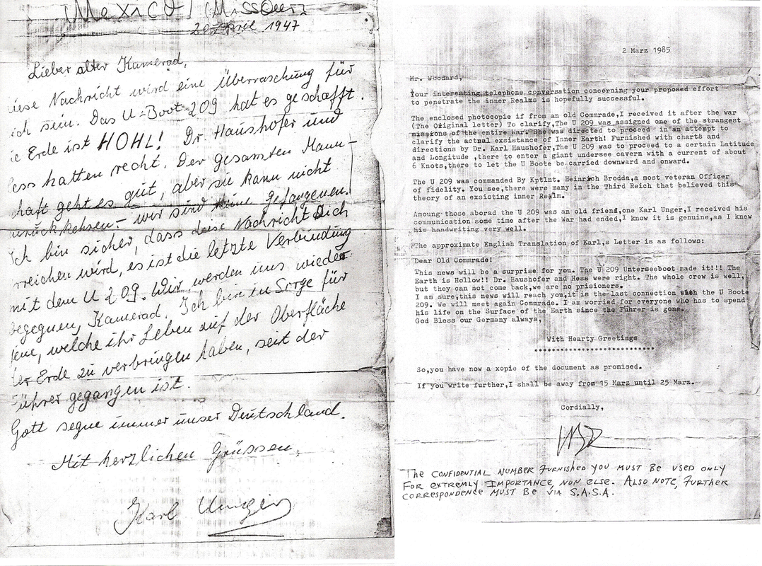 The letter was sent to his friend here on the surface world who gave a copy of it to a Mr. Woodard, who gave a copy to Joe Watson. Karl had sent the letter from the hollow earth through a German colony in Brazil that had found a cavern that reaches to the hollow earth many years previous. This German colony in Brazil is documented in Genesis For a New Age, having supposedly discovered the cavern entrance back in the 1500’s. When one does a search at the German archive website looking for information on the missing U-209 German submarine, it shows that the submarine was indeed reported missing. On July 5, 1943 was it’s last reported position between Greenland and Iceland at coordinates 52°00’N-38°00’W. The report said the Commander of the submarine was Heinrich Brodda. In addition, documents obtained by the soviets at the close of WW2 recently surfaced which shows a 1944 map from the Third Reich detailing not only the direct passageway used by German U-boats to access this subterranean domain, but also a complete map of both hemispheres of the inner realm of Agharta, the mythical name of the inhabited subterranean world 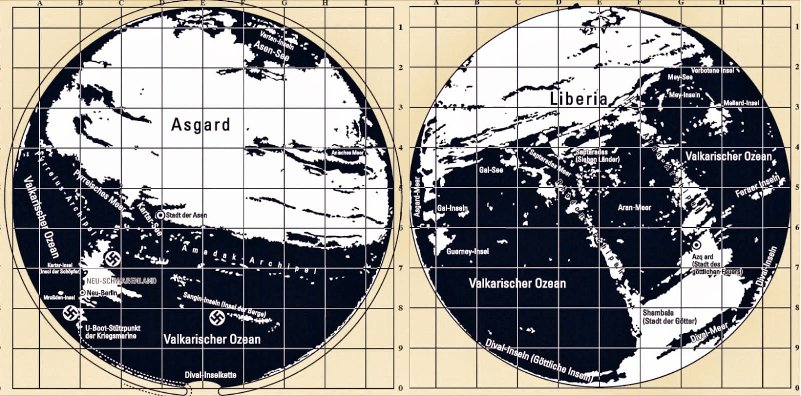 If that seems too unbelievable, compare with those maps, this map done by the famed Tyrolean cartographer and artist Heinrich C. Berann for the National Geographic Society beginning in 1966. The following map clearly shows the continent of Antarctica without its cover of ice:  The intriguing detail here is that there are underwater passageways that run nearly the entire length of the continent and seem to converge at the exact location identified as the opening into the deep inner or subterranean earth. Below is a translation of the Top Secret instructions and specific detailed directions left for the Nazi U-boat Captains to follow in order to reach the inner-world kingdom of Agartha 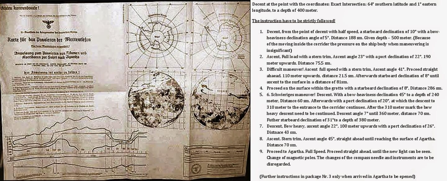 In his groundbreaking bestseller Map of the Ancient Sea Kings, Charles Hapgood (1904-1982), History Professor at Springfield College in Springfield, Massachusetts, first put forth the theory that Atlantis resided in Antarctica and was destroyed by crustal displacement. In his bestseller, When The Sky Fell: In Search of Atlantis, Rand furthered this idea that under the ice of Antarctica exists the remains of Atlantis. Could they be right?  According to a statement from a Russian geologist: these traces were left by vehicles that belonged to an advanced ancient civilization that inhabited our planet 14 million years ago. We all know that numerous religious texts speak of giants that roamed the Earth in the distant past. Even though experts in different fields have different opinions about this possibility, there are others who believe that Ancient Giants did exist and that we can find many traces of their existence today. Geologist Alexander Koltypin believes that the mysterious markings that extend along the Phrygian Valley, in central Turkey, were made by an intelligent race between 12 and 14 million years ago. “We can assume that ancient vehicles with “wheels” were driven into the soft ground, perhaps a wet surface,” said the geologist. “Because of the great weight of these vehicles, they left behind very deep grooves which eventually petrified and turned into evidence.” Geologists are familiar with such phenomena as they have found petrified footprints of dinosaurs that were preserved in the same way. Together with three colleagues, Dr. Koltypin, director of the Natural Science Scientific Research Centre at Moscow’s International Independent Ecological-Political University, traveled to the site in Anatolia, Turkey where these markings can be found. Upon returning from his trip, he described the observed as ‘petrified tracking ruts in rocky tuffaceous [made from compacted volcanic ash deposits’. Dr Koltypin said: ‘All these rocky fields were covered with the ruts left some millions of years ago… we are not talking about human beings.’ ‘We are dealing with some kind of cars or all-terrain vehicles. The pairs of ruts are crossing each other from time to time and some ruts are more deep than the others,’ he added.  According to Dr Koltypin, these tracers were left behind by vehicles 14 million years ago According to Dr Koltypin these mysterious ruts are between 12 to 14 million years old. ‘The methodology of specifying the age of volcanic rocks is very well-studied and worked out,’ he said. Dr Koltypin is one of few experts that actually believes that science needs to change their approach on different matters. He believes that there are many archaeologists who avoid touching this matter since it would ruin all classic theories. ‘As a geologist, I can certainly tell you that unknown antediluvian [pre-Biblical] all-terrain vehicles drove around Central Turkey some 12-to-14 million years ago.’ said Dr. Koltypin. He said: ‘I think we are seeing the signs of the civilisation which existed before the classic creation of this world. Maybe the creatures of that pre-civilisation were not like modern human beings.’ According to Dr. Koltypin and many other archaeologists and experts which have adopted new ways of thinking these ancient “car tracks” are one of the best preserved pieces of evidence which undoubtedly prove the existence of highly advanced ancient civilizations that inhabited our planet in the distant past.  Many researchers believe that there are several pieces of evidence pointing towards the existence of highly advanced ancient civilizations that existed on Earth millions of years ago. “There was no comprehensible system for the tracks but the distance between each pair of tracks ‘is always the same,” added Dr Koltypin. ‘The maximum depth of a rut is about three feet (one metre). On the sides of ruts there can be seen horizontal scratches, it looks like they were left by the ends of the axles used for ancient wheels. ‘We found many ruts with such scratches,’ he said. Is it possible that Dr Koltypin is right? And is it possible that mainstream scientists have ignored these giant pieces of evidence in hopes of preserving their classic and old thinking methods? Is it possible that mainstream experts are afraid of adopting a new approach to ancient history? There are many who believe that with a classic approach, science is becoming less objective. 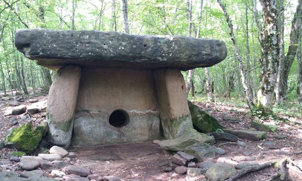 There are many widely known ancient and mysteries structures in the world from the Egyptian pyramids to Stonehenge. However, many others—some smaller but not any less important—are less known. One mysterious set of structures that are not getting enough attention are the megalithic monuments called dolmens. In fact, there are so rarely discussed that living in the Black Sea region for 10 summers, I only found out about them while revisiting the area last year. There are many spread out across the world in varying forms, and about 3,000 of them are all located in the Western Caucasus—particularly near the Black Sea in Russia. Their origins are as mysterious as the Great Pyramid, and there is a whole spiritual movement in Russia behind their current existence. The Origins of the Dolmens: Cosmic Connection? Many dolmens, sometimes referred to as ‘dwarf’ or ‘hobbit houses’ because of their size, are located near Sochi in Russia. They have been intriguing scientists since they were first discovered in 1911 at Krasnaya Polyana—‘red field’ in Russian. Their origins and usage both are highly mysterious—and simply baffling 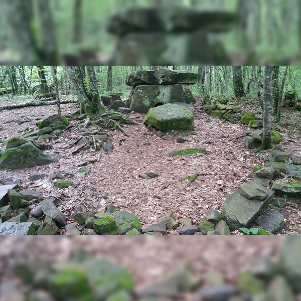 First of all, scientists do not fully understand how they were built—at least not by humans. Involvement of either some giant humans or alien species has been discussed even by non-believers. The tour guide who took me to these structures last summer confirmed the cosmic involvement theory. That is because how these seemingly small structures were built cannot be fully explained. The only theory mainstream science has about their purpose is as burial tombs because there have been bones of the buried found beneath them. Some scientists believe that dolmens were built during the early Bronze Age period or 3,000 BCE. This theory arises from analyzing some of the items found with the buried people — like beads, bronze daggers, and clay items. This age prediction would put them at the same age as the Great Pyramid, whose true age is also still discussed in the scientific community. However, dating the skeletons and the structures by other scientists, it is obvious that the structures were built way earlier than they were used for burial—as early as 25,000 years ago. This prompts a question — were they built for another reason, but used for burial purposes by whoever found them later? Astronomy, Sexual Alchemy, And Other Meanings Each dolmen in the Black Sea region looks very similar. It is a cube-shaped structure with four walls a little shorter than an average adult, a roof, and a perfectly round hole in the middle with a plug that fits it. They are fully carved from stone, and each structure is between 15 and 30 tons. No one can find any evidence of how these stones got carried to their locations often hidden in the woods. These stone walls have 90-degree perfect angles between them and are stacked so perfectly that you cannot insert a thin razor blade between them. A few dolmens have zigzag patterns that are similar to those found at Ireland’s sacred sites. Another symbol that was found on a few dolmens is the Sun Cross from Norse mythology.  Another connection to other sacred sites is that some of the dolmens are aligned with solstices and equinoxes. This suggests that their purpose may have been ceremonial. The round opening in each dolmen may have represented the womb and was connected with sacred sexual alchemy — a rebirth for those who have passed. Other dolmens exist all over Europe, in Belgium, Denmark, France, and other countries. Their shape varies, while most of the western ones follow a similar design. Some people believe that dolmens are energy portals, and there is a spiritual movement behind these structures that are connected to the followers of the teachings of Anastasia — a mysterious Siberian woman described in The Ringing Cedars book series by Vladimir Megre, which has sold over 10 million copies worldwide without any advertising. Mystic Woman Anastasia and the Dolmens Vladimir Megre is a Siberian entrepreneur and writer whose books created a movement. In the 1990s, he wrote a series of books called The Ringing Cedars talking about his journey into the depths of Siberia and meeting a woman, Anastasia, whose life is the opposite from the modern world. Megre describes this series as non-fiction but leaves it vague as to the details of how the information was procured. Many believe Anastasia to be a real woman, others treat her as a spiritual idea, or a spirit visiting Earth. No matter who she is, she has already changed many people’s lives and their perspective of the world. Many eco-villages across Russia were inspired by these books. Anastasia is like no one you have ever met. She is fully interconnected with the animal world and nature. Even in cold Siberia, she needs no clothes; she sleeps next to a bear and inspires tree animals like squirrels to bring her cedar nuts, berries, and other food. Meanwhile, she fully understands the modern world, she just does not believe it is the right path. Instead, she is fully immersed in metaphysical and spiritual studies that she channeled from the cosmos, and from the nature of Man itself. Because she talks a lot about dolmens, the book series sparked interest in these structures. There are people who specifically move to live closer to the dolmens—some set camp in the woods—to go and meditate near these structures every day. I have seen a group of them during my own visit. Anastasia described them as energy portals and that her own ancestral mother figure went into a meditation in one of the structures some 10,000 years ago to communicate with her breastfeeding baby. A few people have seen, and captured in photos, balls of light near the dolmens further confirming their energy connection. Anastasia told Megre that dolmens were used as burials but for a special ritualistic death. Each dolmen was chosen for a person who held extraordinary wisdom and knowledge. They would crawl into a dolmen and stay in meditation until they died, preserving and grounding their wisdom for further generations. This is similar to how monks knew their time of death and would retire to the peak of the mountain, also meditating until their last breath. According to Anastasia, dying in this way stops the person from reincarnating, and their soul stays forever near the dolmen. Regardless of the intent behind building dolmens, people today still feel the strong and positive energy coming from them, and they attract many visitors who were lucky enough to hear about them. The Ringing Cedars book series is available on Amazon.com 
Is it possible that this is how the language of our ancestors sounded in the distant past?
The Indo-European languages constitute the largest family of languages in the world in numbers of speakers. To this incredible list, belong most of the languages of Europe and South Asia (about 150 languages spoken by about 3,200 million people or 45% of the world population). But where do all these languages come from, what is their origin? The first hypothesis of a common origin was proposed in the late eighteenth century by the British scholar Sir William Jones, who noted similarities between four of the oldest known languages: Sanskrit, Latin, Greek and Persian. German philologist and linguist Franz Bopp supported this hypothesis later, after systematically comparing these with other languages, Bopp was able to find many cognates or terms with the same etymological origin only with different phonetic evolution.
This common language of origin has been called Proto-Indo-European, and is believed to have been spoken for thousands of years.
According to researchers, approximately between 4,500 and 2,000 BC, the ancestors of most of Europe and Asia spoke the same native language, a language that is known today as Proto-Indo-European. Linguists are certain they have “reconstructed” the 600 year old language and here below you can listen to what it sounded like. 
Although there is no written record of such language, linguist Andrew Byrd from Kentucky reconstructed this ancient language using only the vocabulary experts are certain existed over 6000 years ago.
Here is the recording:
Byrd is an expert in Indo-European language and focused his studies on phonology. to record the 6000 year old language, and edited and recited his version of a fable called the Sheep and the Horses, and a version of a story called The king and God in PIE (Proto-Indo-European) language.
For all of you who want to know what it actually means in English, check out the text below: A sheep that had no wool saw horses, one of them pulling a heavy wagon, one carrying a big load, and one carrying a man quickly. The sheep said to the horses: “My heart pains me, seeing a man driving horses.” The horses said: “Listen, sheep, our hearts pain us when we see this: a man, the master, makes the wool of the sheep into a warm garment for himself. And the sheep has no wool.” Having heard this, the sheep fled into the plain. Prometheus anyone? According To Numerous Ancient Accounts, There Was A Time When The Moon Did Not Exist In The Sky8/8/2021  In ancient writings and traditions one can find proof of a time when the moon did not exist. Democretus and Anaxagoras mention that there was a time when no moon could be seen in the night skies. In describing the history of the Greek region of Arcadia, Aristotle writes that the Pelasgians lived in the area since very old times; at a time when the moon did not exist. Apollonios from Rhodes mentions something similar; he talks about a time when not all of the celestial objects existed in the sky; before the time of Deucalion’s and Pyrra’s generation (before the cataclysm); when the moon did not exist and the only humans that existed were the Pelasgians living on the mountains of Arcadia (region in Greece). These inhabitants of Arcadia where also known as Proselenes (meaning “those that were before moon” in Greek). In Plutarch’s work “Morals” we find the following: “There were Arcadians of Evander’s following, the so-called pre-Lunar people.” Similarly, Ovid wrote: “The Arcadians are said to have possessed their land before the birth of Zeus, and the folk is older than the Moon.” Stephanus of Byzantium wrote: “Arcadians and females, both exist before the moon”. Hippolytus refers to a legend that “Arcadia brought forth Pelasgus, of greater antiquity than the moon.” Lukianos in his Astrology says that “the Arcadians affirm in their folly that they are older than the moon”.  In Plutarch’s work “Morals” we find the following: “There were Arcadians of Evander’s following, the so-called pre-Lunar people.” Similarly, Ovid wrote: “The Arcadians are said to have possessed their land before the birth of Zeus, and the folk is older than the Moon.” Stephanus of Byzantium wrote: “Arcadians and females, both exist before the moon”. Hippolytus refers to a legend that “Arcadia brought forth Pelasgus, of greater antiquity than the moon.” Lukianos in his Astrology says that “the Arcadians affirm in their folly that they are older than the moon”. Evidence has also been found in other parts of the world. In Bolivia symbols on the wall of the courtyard of Kalasasaya (built in 13,000 BC) provide evidence that the moon came into orbit around the Earth at a specific moment in time thousands of years ago, long before what mainstream historians refer to as recorded history. Moreover the calendar gate in the same site provides evidence that a smaller satellite once rotated around the Earth. The oral traditions of Colombian Indians of the Bogota highlands in the eastern Corldilleras of Colombia refer to a time before the moon. “In the earliest times, when the moon was not yet in the heavens,” say the tribesmen of Chibchas. Africa also provides its own evidence. According to Zulu legend, the moon was brought hundreds of generations ago by two brothers of alien form, Wowane and Mpanku. What does all this mean? The ancient memory of an Earth inhabited by humans without a moon has passed from generations to generations forming the traditions of numerous civilizations. How did the moon get there?  The Earth Without The MoonThe period when the Earth was Moonless is probably the most remote recollection of mankind. Democritus and Anaxagoras taught that there was a time when the Earth was without the Moon. Aristotle wrote that Arcadia in Greece, before being inhabited by the Hellenes, had a population of Pelasgians, and that these aborigines occupied the land already before there was a moon in the sky above the Earth; for this reason they were called Proselenes. Apollonius of Rhodes mentioned the time “when not all the orbs were yet in the heavens, before the Danai and Deukalion races came into existence, and only the Arcadians lived, of whom it is said that they dwelt on mountains and fed on acorns, before there was a moon.” (3) Plutarch wrote in The Roman Questions: “There were Arcadians of Evander’s following, the so-called pre-Lunar people.”(4) Similarly wrote Ovid: “The Arcadians are said to have possessed their land before the birth of Jove, and the folk is older than the Moon.” (5) Hippolytus refers to a legend that “Arcadia brought forth Pelasgus, of greater antiquity than the moon.”(6) Lucian in his Astrology says that “the Arcadians affirm in their folly that they are older than the moon.”(7) Censorinus also alludes to the time in the past when there was no moon in the sky.(8) Some allusions to the time before there was a Moon may be found also in the Scriptures. In Job 25:5 the grandeur of the Lord who “Makes peace in the heights” is praised and the time is mentioned “before [there was] a moon and it did not shine.” Also in Psalm 72:5 it is said: “Thou wast feared since [the time of] the sun and before [the time of] the moon, a generation of generations.” A “generation of generations” means a very long time. Of course, it is of no use to counter this psalm with the myth of the first chapter of Genesis, a tale brought down from exotic and later sources. The memory of a world without a moon lives in oral tradition among the Indians. The Indians of the Bogota highlands in the eastern Cordilleras of Colombia relate some of their tribal reminiscences to the time before there was a moon. “In the earliest times, when the moon was not yet in the heavens,” say the tribesmen of Chibchas.(9) There are currently three theories of the origin of the moon: 1) The Moon originated at the same time as the Earth, being formed substantially from the same material, aggregating and solidifying. 2) The Moon was formed not in the vicinity of the Earth, but in a different part of the solar system, and was later captured by the Earth. 3) The Moon was originally a portion of the terrestrial crust and was torn out, leaving behind the bed of the Pacific. All three theories claim the presence of the Moon on an orbit around the Earth for billions of years. Mythology may supply each of these views with some support (Genesis I for the first view; the birth of Aphrodite from the sea for the third view; Aphrodite’s origin in the disruption of Uranus, and also the violence of Sin—the Babylonian Moon—seems to support the second view). Since mankind on both sides of the Atlantic preserved the memory of a time when the Earth was without the Moon, the first hypothesis, namely, of the Moon originating simultaneously with the Earth and in its vicinity, is to be excluded, leaving the other two hypotheses to compete between themselves. We have seen that the traditions of diverse peoples offer corroborative testimony to the effect that in a very early age, but still in the memory of mankind, no moon accompanied the Earth.(10) Since human beings already peopled the Earth, it is improbable that the Moon sprang from it: there must have existed a solid lithosphere, not a liquid earth. Thus while I do not claim to know the origin of the Moon, I find it more probable that the Moon was captured by the Earth. Such an event would have occurred as a catastrophe.(11) If the Moon’s formation took place away from the Earth,(12) its composition may be quite different. There is no evidence to suggest whether the Moon was a planet, a satellite of another planet, or a comet at the time of its capture by the Earth. Whatever atmosphere it may have had(13) was pulled away by the Earth, by other contacting bodies, or dissipated in some other way. Since the time the Moon began to accompany the Earth, it underwent the influence of contacts with comets and planets that passed near the Earth in subsequent ages. The mass of the Moon being less than that of the Earth, the Moon must have suffered greater disturbances in cosmic contacts. During these contacts the Moon was not carried away: this is due to the fact that no body more powerful than the Earth came sufficiently close to the Moon to take it away from the Earth for good; but in the contacts that took place the Moon was removed repeatedly from one orbit to another. The variations in the position of the Moon can be read in the variations in the length of the month. The length of the month repeatedly changed in subseqent catastrophic events—and for this there exists a large amount of supporting evidence. In these later occurrences the Moon played a passive role, and Zeus in the Iliad advised it (Aphrodite) to stay out of the battle in which Athene and Ares (Venus and Mars) were the main contestants.  This is one of Africa’s oldest written languages. Archaeologists excavating a vast and ancient “city of the dead” in Africa have recovered the largest collection of texts in the mysterious language of the Kushites. Dating back to 2,700 years ago, the find includes extraordinary tablets commemorating the dead. The items hail from a site called Sedeinga in Sudan, known for the ruins of a temple dedicated to the 14th century BCE Egyptian queen Tiye, the grandmother of Tutankhamun. But between the 7th century BCE and the 4th century CE, the site was a significant necropolis — city of the dead — for the kingdoms of Napata and Meroe, which mixed Egyptian traditions with their own. Combined, the two kingdoms were known as the kingdom of Kush by their Egyptian neighbours. Very little information remains about these cultures, but funerary items can tell us a lot. Although much of the necropolis is in ruins, it is large — containing the remains of at least 80 brick pyramids and 100 tombs. It is from these tombs that the artefacts were recovered by a research team led by the French National Centre for Scientific Research (CNRS) and the French Archaeological Unit Sudan Antiquities Service (SFDAS).   The Maat lintel. (Vincent Francigny/Sedeinga archaeological mission) The tombs, lintels and steles — a type of tablet stone used as a commemorative monument — represent the largest collection of texts in Meroitic. It’s the earliest known written language of sub-Saharan Africa, written in characters borrowed from the ancient Egyptians — at least some of whom, genomic data suggests, were more closely related to the people of the Near East than middle Africa. “The Meroitic writing system, the oldest of the sub-Saharan region, still mostly resists our understanding,” Vincent Francigny, an archaeologist with the SFDAS and co-director of the excavation, told Live Science. “While funerary texts, with very few variations, are quite well-known and can be almost completely translated, other categories of texts often remain obscure. In this context, every new text matters, as they can shed light on something new.” Most of the tombs and pyramids date back to the earlier Napata kingdom, the archaeologists found. Five centuries later, the Meroitics added new structures to these earlier buildings — chapels of brick and sandstone on the pyramids’ western walls, built for the worship of the dead.  The stele dedicated to Lady Meliwarase. (Vincent Francigny/Sedeinga archaeological mission) One significant find was a chapel lintel depicting Maat, the Egyptian goddess of law, balance, order, harmony, peace and justice. It dates from the 2nd century CE, and is the first known extant representation of the goddess that shows her with African features. They also found two commemorative texts dedicated to women of high rank. Maliwarase of Nubia, we know from her stele, was sister to two grand priests of the Sun god Amon, and mother to the governor of Faras, a city on the second cataract of the Nile. Adatalabe was described in four lines on the lintel of a sepulchre. She was related to a prince of the reigning family of Meroe.  The lintel describing Lady Adatalabe. (Vincent Francigny/Sedeinga archaeological mission) The fact that both items describe women is not a stroke of luck. There is strong evidence to suggest that, unlike the Egyptians, the Nubian people were matrilineal, or at least that women were held in very high esteem. They may have borrowed from other cultures, but their identity was their own. “Meroe was a kingdom where, among others, some Egyptian cultural and religious concepts were borrowed and adapted to local traditions,” Francigny said. “We should not see Meroe as a passive recipient for foreign influences – instead, Meroites were very selective about what they could borrow to serve the purpose of the royal family and the development of their pharaonic, but non-Egyptian, society.” Work on the site is ongoing, and is planned to continue until 2020.  The "phantom attack" took place in council offices while guards were patrolling at night, claims the mayor of a small mountain city in Colombia. In the bizarre video, a guard can be seen walking down a hallway before seemingly being violently thrown into a wall by an unseen force. The startled man falls to the floor and then slowly crawls away from the point of impact until two of his coworkers quickly arrive on the scene. 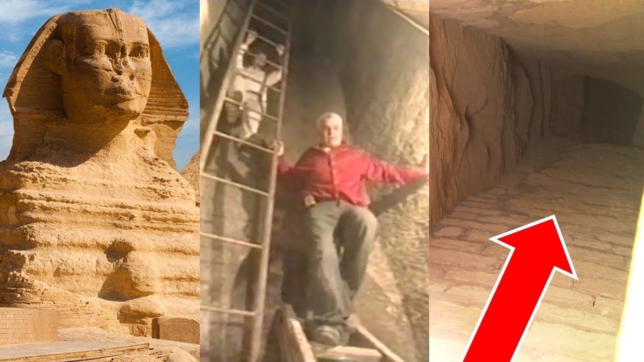 A quarter of a century ago, researchers Robert Schoch and Robert Bauval were at the centre of two controversial debates in Egyptology: Schoch, with his geological redating of the Great Sphinx to a period earlier than its supposed builder, the Pharaoh Khafre; and Bauval, with his ‘Orion Correlation Theory’ that suggested the three famous pyramids of Giza were laid out to mimic the stars in the ‘belt’ of the constellation Orion. Now, in 2017, Schoch and Bauval have teamed up again to revisit the Sphinx debate. Hot on the heels of their recent book collaboration, Origins of the Sphinx, the pair have now – along with independent researcher Manu Seyfzadeh – published an academic paper titled “A New Interpretation of a Rare Old Kingdom Dual Title: The King’s Chief Librarian and Guardian of the Royal Archives of Mehit” (free full PDF download available from that abstract page). Don’t let the rather staid title fool you – the paper continues on in the same vein as Schoch and Bauval’s previous radical Egyptological theories. They point out some textual (i.e. hieroglyphic) evidence suggesting the Sphinx predates Khafre’s reign by many centuries – and also that the hieroglyphs representing it may be suggestive that the Sphinx is guardian of a hidden ‘hall of records’. One of the more pointed criticisms of the idea of an older Great Sphinx is that no written evidence exists which proves a lion-like monument stood on the Giza Plateau before its currently accepted date of creation during the Old Kingdom, circa 2500 B.C.E. In this paper, we would like to address this contention by showing evidence to the contrary. Researchers Seyfzadeh, Schoch, and Bauval focus on a part of the title of a number of Old Kingdom Pharaohs’ viziers that hasn’t yet been properly translated. The official title is made up of seven distinct, vertically aligned hieroglyphs: Axe – Reed and Inkwell – Sedge – Bread Loaf – Axe – Bent Rod – Recumbent Lion. The last two symbols – the ‘bent rod’ and ‘recumbent lion’, which are strangely combined, with the rod-like object connected to the back of the lioness – have puzzled translators thus far.  The title has been traced right back to the beginnings of Dynastic Egypt, being found on seals of Narmer imprinted on yellow clay locks used to securely shut vases and pouches. But nobody has so far been able to explain why the bent rod emerges from (or enters) the back of a lioness, or the combined symbol’s connection with royal scribes/viziers and locks used for shutting vessels. However, the trio of researchers say that they now have a possibly theory: We believe the most likely meaning [for the rod symbol] is “key”… It is known that the ancient Egyptians had developed a lock and key device to secure an entree by at least the Middle Kingdom. By then, the key was a tooth-brush like object used to displace wooden pins obstructing a wooden bolt. [H]owever, we do not think this word stood on its own. Instead it, in combination with Mehit, formulated the more abstract concept of a guard, explaining why it was used as a symbol on seals imprinted onto clay locks to secure tomb goods such as vases and pouches… Here, we are now able to associate scribes with a lock-secured facility either dedicated to a lion goddess or, in fact, a facility made in the shape of a recumbent lioness. This is further corroborated by the way the rod symbol ostensibly enters the back of the lioness as if the latter physically bore the lock belonging to this key. The most obvious choice for a location ‘in the shape of a recumbent lioness’, say the three researchers, “ought to be the monumental Great Sphinx on the Giza Plateau. And what might ‘the facility’ at the Sphinx be? Seismic probing has also revealed a hollow space beneath the Great Sphinx’s northern paw and the signal demarcations and geometry suggest this space was man-made, raising the intriguing possibility of a hidden and secured stony vault within the bedrock under the Great Sphinx where ancient records may have been kept. Seyfzadeh, Schoch, and Bauval believe that the name of the Great Sphinx during the Old Kingdom and even before was Mehit, a feline goddess. And they note there may be some further physical evidence to link the two. They point out “a peculiar feature of the neck area of the Great Sphinx” – an oblique limestone ridge – may mimic the ornamental rings depicted on some of the strange ‘recumbent lion’ hieroglyphs. Though it’s unknown whether the hieroglyphs might have been modeled on the Sphinx, or the Sphinx on the hieroglyphs.  In summary, the researchers say… …we have presented written, hieroglyphically recorded evidence that: a) two, heretofore incompletely translated, tandem titles conferred to Hemiunu, Wepemnefret, and Hesy-Re are semantically interwoven within the context of overseeing the creation and secure storage of scribal documents; b) secure storage was concretely symbolized by a key-like device metaphorically “locking” the Upper Egyptian goddess Mehit; c) this mythical metaphor of Mehit’s aspect as a recumbent lioness guardian so symbolized was based on her physical, monumental stony counterpart on the Giza Plateau long before the Fourth Dynasty, corroborating previous archeo-astronomical, geological, and seismographic evidence that the Great Sphinx is a modification of a much more ancient monument; and d) beneath this monument is a man-made, ornamented palace-like façade, and bolt lock-gated vault with chambers known to both 1st and 18th Dynasty kings, likewise corroborating prior seismographic evidence of a non-random, likely man-made, void beneath the north-east zone of the Great Sphinx. Our interpretation of this textual evidence is unequivocally testable and initially only requires a small drill hole and optic equipment to explore this already known void. And for those who might be saying “maybe the recumbent lion is just a picture of a recumbent lion?”, Seyfzadeh, Schoch, and Bauval have perhaps one of most quotable counter-responses in an academic paper: “One does not insert a key into a real lioness”. Well, not unless you’ve got some good running legs on you… Remember too that you can find more up-to-date discussion of the mysteries of the Giza Plateau in Schoch and Bauval’s recent book, Origins of the Sphinx.  There are some mysterious marks which some call airports near the ancient city of Dunhuang in Gansu Province, I believe. I will provide solid evidence that these are nothing like an airport that I have ever heard of and I am a retired engineering manager and a pilot. If one goes to Google earth an enters the latitude and longitude provided on the bottom of the first image, you can move the cursor around and see that the marks are not built up in elevation as an airport would be. Road graders and compactors are needed to pack a field sufficiently to safely take the extreme pressure that landing gears make at times. Any yielding of the dirt would cause the plane to spin out of control. Of course, there are no support buildings or taxiways to parking areas. One may also see that common truck traffic has made tracks out across a number of the marks and therefore it cannot be paved or a prepared surface. If the marks were graded and compacted, they would be nearly perfectly level lengthwise and side to side. When tracing the contour with GE they still show the general contour of the area around them. Water erosion on the west mark indicates that this desert area was once quite a bit moister and the marks were already there during heavy rains or snow runoff. Even the darker colored areas which one might be tempted to think are paved show signs of erosion.  P.S. Ancient or Modern? This mysterious “grid” was discovered in China (see Google Earth coordinates on the pictures). It is 31km x 31 km. When was it made and for what purpose? Not far (NW) from the above location we find another grid (erosion suggests it was made very long ago – perhaps in ancient times?)  More grids nearby:  Mysterious Nazca-like Site near Dunhuang in China Dunhuang is a city (pop. 187,578 (2000) in Jiuquan, Gansu province, China. It was a major stop on the ancient Silk Road. It was also known at times as Shachou, or ‘City of Sands’. It is situated in a rich oasis containing Crescent Lake and Mingsha Shan, “Echoing-Sand Mountain”. Mingsha Shan is so named for the sound of the wind whipping off the dunes, the singing sand phenomenon. It commands a very strategic position at the crossroads of the ancient Southern Silk Route and the main road leading from India via Lhasa to Mongolia and Southern Siberia, as well as controlling the entrance to the narrow Gansu Corridor which led straight to the heart of the north Chinese plains and the ancient capitals of Chang’an (today known as Xi’an) and Luoyang. 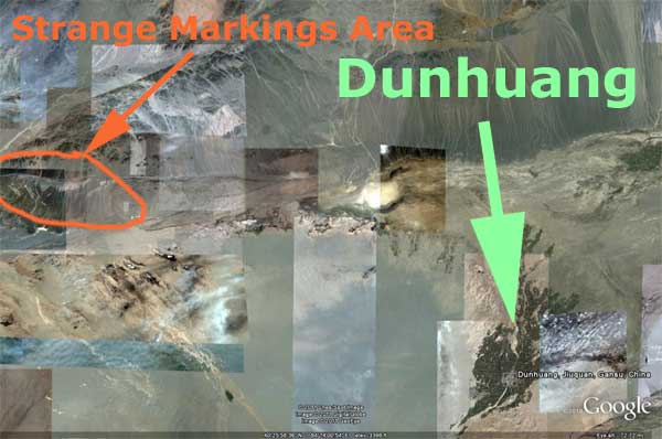 Mysterious Nazca-like site is located 100 km W from Dunhuang, Jiuquan, Gansu, China. Google Earth satellite photos show few areas with strange geometric patterns (geoglyphs). There are also 2 areas which look like “landing strips”. Perhaps it is a military installation, however most of the strange areas are difficult to interpret. Noticeable erosion indicates that some of the patterns could be ancient. 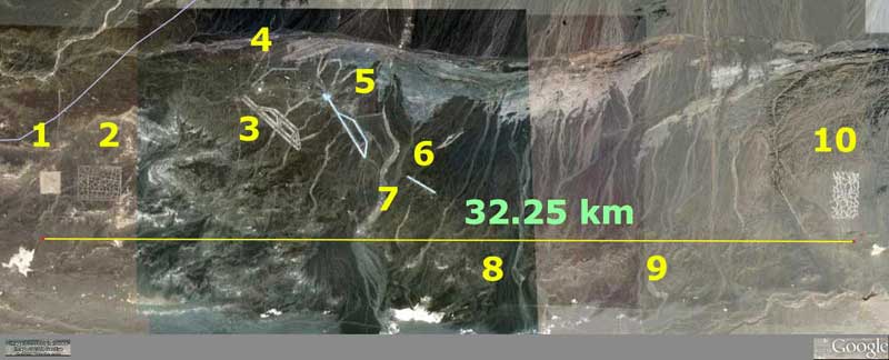 Here are few Google Earth images of the most interesting areas: 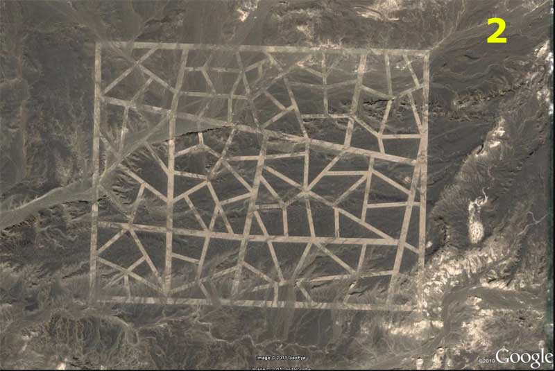  Here are coordinates for Google Earth: Latitude: 40°28’43.07″N Longitude: 93°28’36.42″E |

Ufomania Store
Helena MatiasEditor 
Please visit and subscribe our youtube channel
Archives
May 2024
Please take a look below at the amazing work of Author and researcher Stephen Quayle
Categories
All
|